

Key Insights
The global Aerial LiDAR Mapping Service market is experiencing robust growth, driven by escalating demand for precise geographical data across diverse sectors. Expected to reach an estimated market size of approximately $2.5 billion by 2025, the market is projected to expand at a Compound Annual Growth Rate (CAGR) of around 15% during the forecast period of 2025-2033. This significant expansion is fueled by key drivers such as the increasing adoption of LiDAR technology in urban planning and development for 3D city modeling, infrastructure management, and disaster response. Furthermore, the forestry and agriculture sectors are leveraging LiDAR for detailed vegetation analysis, crop monitoring, and sustainable land management practices. The transportation and infrastructure segment benefits from LiDAR's application in road and rail network design, maintenance, and safety assessments, while mining and mineral exploration utilize it for resource mapping and volumetric calculations. These applications are propelling the market forward by providing unparalleled accuracy and efficiency in data acquisition and analysis.
Emerging trends such as the integration of artificial intelligence and machine learning with LiDAR data are further enhancing the value proposition of aerial LiDAR mapping services, enabling more sophisticated data interpretation and predictive analytics. The miniaturization and increased affordability of LiDAR sensors are also contributing to wider adoption, particularly among smaller enterprises and for niche applications. However, the market faces certain restraints, including the high initial investment costs for advanced LiDAR systems and the specialized expertise required for data processing and analysis. Geographically, North America currently leads the market, owing to substantial government investments in infrastructure projects and a well-established geospatial industry. The Asia Pacific region is exhibiting the fastest growth, driven by rapid urbanization, infrastructure development, and increasing adoption of advanced mapping technologies in countries like China and India. The market's segmentation by application reveals Urban LiDAR Mapping as a dominant segment, followed by Forestry and Agriculture, reflecting the widespread need for precise spatial intelligence.
This comprehensive report offers an in-depth analysis of the global Aerial Lidar Mapping Service market, providing crucial insights for industry stakeholders. Spanning the historical period from 2019 to 2024 and projecting growth through 2033, with a base and estimated year of 2025, this study delves into market dynamics, growth trends, regional dominance, product landscapes, key challenges, and emerging opportunities.
Aerial Lidar Mapping Service Market Dynamics & Structure
The global Aerial Lidar Mapping Service market is characterized by a moderately concentrated structure, with a mix of established global players and emerging regional specialists. Technological innovation remains a primary driver, fueled by advancements in sensor technology, data processing algorithms, and cloud computing capabilities, enabling higher resolution, faster data acquisition, and more sophisticated analytical outputs. Regulatory frameworks, particularly concerning data privacy, airspace regulations, and industry standards, play a significant role in shaping market accessibility and operational procedures. Competitive product substitutes include traditional photogrammetry and ground-based surveying methods, though LiDAR's accuracy and efficiency in complex environments increasingly differentiate it. End-user demographics are diverse, encompassing government agencies, infrastructure developers, natural resource managers, and private enterprises across various sectors. Mergers and acquisitions (M&A) are a notable trend, with larger entities acquiring smaller, innovative firms to expand service portfolios and geographical reach. For instance, recent years have seen an average of 5-7 M&A deals annually within the broader geospatial services sector, with a notable uptick in acquisitions of LiDAR-specific companies. Barriers to innovation include the high cost of initial investment in advanced LiDAR equipment and specialized software, alongside the requirement for highly skilled personnel.
- Market Concentration: Moderately concentrated, with key players holding significant market share, but with room for specialized and regional providers.
- Technological Innovation Drivers: Miniaturization of LiDAR sensors, AI-powered point cloud classification, real-time data processing, and integration with drone technology.
- Regulatory Frameworks: Evolving drone regulations, data security protocols, and standardized data formats are critical.
- Competitive Product Substitutes: Photogrammetry, traditional surveying, radar imaging.
- End-User Demographics: Government (urban planning, infrastructure), Forestry & Agriculture, Transportation, Mining, Environmental Monitoring.
- M&A Trends: Consolidation driven by the need for integrated geospatial solutions and expanded service offerings.
Aerial Lidar Mapping Service Growth Trends & Insights
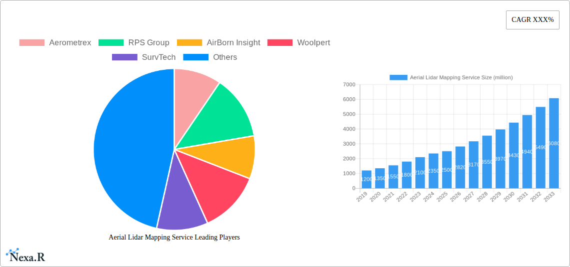
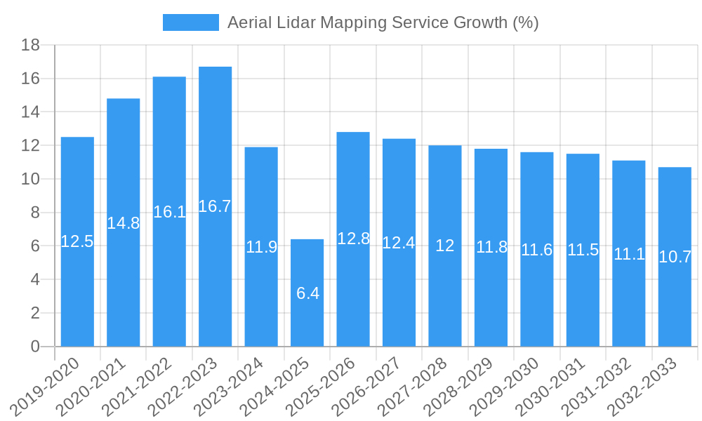
The global Aerial Lidar Mapping Service market is poised for robust expansion, driven by an escalating demand for high-accuracy 3D spatial data across a multitude of applications. The market size is projected to grow from approximately $2,500 million in 2025 to an estimated $4,800 million by 2033, exhibiting a Compound Annual Growth Rate (CAGR) of roughly 8.5% during the forecast period. Adoption rates are accelerating as organizations recognize the significant return on investment offered by LiDAR technology in terms of reduced project timelines, enhanced safety, and improved decision-making. Technological disruptions, such as the integration of advanced AI and machine learning for automated data analysis and feature extraction, are further propelling market penetration. Consumer behavior is shifting towards seeking comprehensive geospatial solutions rather than standalone data acquisition, leading to increased demand for integrated mapping and analysis services. The increasing affordability and accessibility of drone-based LiDAR systems are democratizing access to this technology, particularly for smaller enterprises and local government bodies. The historical data from 2019-2024 indicates a steady upward trend, with the market experiencing an average annual growth of 7%. This momentum is expected to continue, fueled by ongoing infrastructure development projects worldwide and a growing emphasis on smart city initiatives. The ability of LiDAR to penetrate dense vegetation and provide precise ground elevation data is also a significant factor in its expanding use in forestry and environmental management.
Dominant Regions, Countries, or Segments in Aerial Lidar Mapping Service
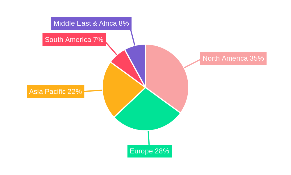
North America currently dominates the global Aerial Lidar Mapping Service market, driven by substantial investments in transportation and infrastructure development, alongside a mature geospatial data ecosystem. The United States, in particular, plays a pivotal role due to its extensive infrastructure renewal programs, strong emphasis on smart city development, and proactive government adoption of geospatial technologies for urban planning and environmental monitoring. The Transportation and Infrastructure segment consistently emerges as a leading application, accounting for an estimated 35% of the total market share. This dominance is fueled by the need for accurate topographic data for road construction, bridge inspection, railway development, and utility corridor mapping. Urban LiDAR mapping, a specialized type within the broader application, is also a significant contributor, enabling detailed 3D city models for disaster management, urban planning, and architectural studies, representing approximately 25% of the market.
In terms of Type, Topographic LiDAR Mapping commands the largest market share, estimated at over 40%, due to its fundamental role in creating detailed elevation models for a wide array of projects. However, Vegetation LiDAR Mapping is experiencing rapid growth, driven by forestry management, agricultural precision farming, and carbon stock assessment initiatives.
Key Drivers for Dominance:
- Economic Policies & Infrastructure Spending: Significant government funding allocated to national infrastructure projects, including road networks, public transportation systems, and smart city initiatives in countries like the US, Canada, and Mexico.
- Technological Adoption Rates: High uptake of advanced geospatial technologies by private sector firms and government agencies, fostered by established research and development sectors.
- Environmental Concerns: Increasing focus on climate change mitigation and adaptation, driving demand for LiDAR in forest inventory, wildfire risk assessment, and coastal zone management.
- Skilled Workforce: Availability of a highly skilled workforce in surveying, data processing, and GIS analysis.
The market share in North America is estimated to be around 38% of the global market in 2025, with a projected growth rate of 9.2% during the forecast period. Europe follows closely, with strong contributions from countries like Germany, the UK, and France, largely driven by similar infrastructure needs and environmental initiatives. Asia-Pacific is the fastest-growing region, propelled by rapid urbanization and infrastructure development in countries like China and India, coupled with increasing adoption of precision agriculture technologies.
Aerial Lidar Mapping Service Product Landscape
The Aerial Lidar Mapping Service product landscape is defined by continuous innovation in sensor technology and data processing software. LiDAR systems are becoming increasingly compact, lightweight, and cost-effective, enabling their integration with a wider range of aerial platforms, including drones. This has led to a surge in high-resolution point cloud data generation, offering unparalleled accuracy in capturing topographical features, vegetation structure, and urban environments. Key product innovations include the development of multi-return LiDAR for enhanced penetration through dense canopies and advancements in real-time kinematic (RTK) and post-processed kinematic (PPK) GPS technology for improved georeferencing accuracy. Furthermore, specialized LiDAR sensors are emerging for bathymetric mapping, capable of penetrating water to map underwater topography. Software solutions are increasingly incorporating AI and machine learning for automated classification of point clouds, feature extraction (e.g., buildings, power lines, trees), and 3D model generation, significantly reducing manual processing time and costs. Unique selling propositions revolve around accuracy, speed of data acquisition, cost-effectiveness, and the ability to generate comprehensive 3D datasets for diverse applications.
Key Drivers, Barriers & Challenges in Aerial Lidar Mapping Service
The Aerial Lidar Mapping Service market is propelled by several key drivers. The accelerating demand for high-accuracy 3D data in infrastructure development, urban planning, and environmental management is paramount. Advancements in LiDAR technology, leading to more efficient and affordable solutions, further fuel adoption. Government initiatives promoting smart cities and digital infrastructure are also significant catalysts. The increasing need for detailed vegetation analysis in forestry and agriculture for precision farming and carbon monitoring also contributes to market growth.
However, the market faces significant barriers and challenges. The substantial initial investment required for high-end LiDAR equipment and specialized software remains a hurdle for smaller players. A shortage of skilled professionals capable of operating LiDAR systems and processing the resulting complex datasets can also limit growth. Stringent aviation regulations for drone operations, particularly in populated areas, can impact deployment flexibility and timelines. Furthermore, competition from established traditional surveying methods and emerging alternative technologies presents a continuous challenge. Supply chain disruptions for specialized components and the ongoing need for continuous technological upgrades add to operational complexities.
Emerging Opportunities in Aerial Lidar Mapping Service
Emerging opportunities in the Aerial Lidar Mapping Service sector are largely driven by the expansion of its application into new and evolving domains. The growing focus on climate change adaptation and resilience is creating demand for LiDAR-based flood mapping, coastal erosion monitoring, and detailed urban heat island analysis. The integration of LiDAR with other sensor technologies, such as hyperspectral and thermal imaging, offers new avenues for detailed environmental assessments and resource management. Furthermore, the burgeoning drone delivery industry and the development of autonomous vehicle infrastructure present new markets for highly accurate and dynamic mapping services. The increasing adoption of Digital Twins for infrastructure management and urban planning also signifies a significant growth area, where LiDAR-derived data forms the foundational layer. Untapped markets in developing regions with rapid urbanization and infrastructure growth also present considerable potential.
Growth Accelerators in the Aerial Lidar Mapping Service Industry
Several growth accelerators are poised to propel the Aerial Lidar Mapping Service industry forward. Technological breakthroughs, particularly in miniaturization of sensors, increased data acquisition speeds, and sophisticated AI-driven data processing, will continue to enhance efficiency and reduce costs. Strategic partnerships between LiDAR technology providers, software developers, and end-user industries will foster integrated solutions and expand market reach. Market expansion strategies, including the development of subscription-based service models and cloud-based data platforms, will make LiDAR services more accessible to a broader customer base. The increasing awareness and adoption of LiDAR for critical infrastructure maintenance and asset management, coupled with supportive government policies and investments in digital transformation initiatives, will further accelerate industry growth.
Key Players Shaping the Aerial Lidar Mapping Service Market
- Aerometrex
- RPS Group
- AirBorn Insight
- Woolpert
- SurvTech
- NM Group
- AUAV
- LiDAR Solutions
- Measure Australia
- Land Surveys
- Cooper Aerial Surveys
- DJ&A
- SAM
- Geosoft
- McKim & Creed
- ACI
- Prius Intelli
- Basemap Consulting
- Synergy Mapping
- Aerial Precision
- Aerial Surveys
- LiDAR Services International
- AIRPIX
Notable Milestones in Aerial Lidar Mapping Service Sector
- 2019: Increased adoption of drone-based LiDAR for rapid infrastructure inspection and environmental surveys.
- 2020: Advancements in AI-powered point cloud classification lead to more automated data analysis.
- 2021: Expansion of bathymetric LiDAR technology for clearer underwater mapping.
- 2022: Growth in cloud-based LiDAR data processing platforms for enhanced accessibility and collaboration.
- 2023: Increased focus on vegetation LiDAR for precise forest carbon stock assessment and management.
- 2024: Integration of LiDAR with other remote sensing technologies for comprehensive geospatial solutions.
In-Depth Aerial Lidar Mapping Service Market Outlook
The future outlook for the Aerial Lidar Mapping Service market is exceptionally promising, driven by a confluence of technological innovation and expanding application frontiers. Growth accelerators such as the continued miniaturization and cost reduction of LiDAR sensors, coupled with the maturation of AI algorithms for data processing, will democratize access and unlock new market segments. Strategic partnerships will be crucial in developing end-to-end geospatial solutions, integrating LiDAR data seamlessly into existing industry workflows. Market expansion will be fueled by significant global investments in smart city initiatives, sustainable infrastructure, and advanced environmental monitoring programs. The increasing demand for high-resolution, accurate 3D data across sectors like renewable energy, disaster management, and precision agriculture positions Aerial Lidar Mapping Services as an indispensable tool for future development and sustainability efforts.
Aerial Lidar Mapping Service Segmentation
-
1. Application
- 1.1. Urban
- 1.2. Forestry and Agriculture
- 1.3. Transportation and Infrastructure
- 1.4. Mining and Mineral Exploration
- 1.5. Others
-
2. Type
- 2.1. Topographic LiDAR Mapping
- 2.2. Bathymetric LiDAR Mapping
- 2.3. Vegetation LiDAR Mapping
- 2.4. Urban LiDAR Mapping
- 2.5. Others
Aerial Lidar Mapping Service Segmentation By Geography
-
1. North America
- 1.1. United States
- 1.2. Canada
- 1.3. Mexico
-
2. South America
- 2.1. Brazil
- 2.2. Argentina
- 2.3. Rest of South America
-
3. Europe
- 3.1. United Kingdom
- 3.2. Germany
- 3.3. France
- 3.4. Italy
- 3.5. Spain
- 3.6. Russia
- 3.7. Benelux
- 3.8. Nordics
- 3.9. Rest of Europe
-
4. Middle East & Africa
- 4.1. Turkey
- 4.2. Israel
- 4.3. GCC
- 4.4. North Africa
- 4.5. South Africa
- 4.6. Rest of Middle East & Africa
-
5. Asia Pacific
- 5.1. China
- 5.2. India
- 5.3. Japan
- 5.4. South Korea
- 5.5. ASEAN
- 5.6. Oceania
- 5.7. Rest of Asia Pacific
Aerial Lidar Mapping Service REPORT HIGHLIGHTS
| Aspects | Details |
|---|---|
| Study Period | 2019-2033 |
| Base Year | 2024 |
| Estimated Year | 2025 |
| Forecast Period | 2025-2033 |
| Historical Period | 2019-2024 |
| Growth Rate | CAGR of XXX% from 2019-2033 |
| Segmentation |
|
Table of Contents
- 1. Introduction
- 1.1. Research Scope
- 1.2. Market Segmentation
- 1.3. Research Methodology
- 1.4. Definitions and Assumptions
- 2. Executive Summary
- 2.1. Introduction
- 3. Market Dynamics
- 3.1. Introduction
- 3.2. Market Drivers
- 3.3. Market Restrains
- 3.4. Market Trends
- 4. Market Factor Analysis
- 4.1. Porters Five Forces
- 4.2. Supply/Value Chain
- 4.3. PESTEL analysis
- 4.4. Market Entropy
- 4.5. Patent/Trademark Analysis
- 5. Global Aerial Lidar Mapping Service Analysis, Insights and Forecast, 2019-2031
- 5.1. Market Analysis, Insights and Forecast - by Application
- 5.1.1. Urban
- 5.1.2. Forestry and Agriculture
- 5.1.3. Transportation and Infrastructure
- 5.1.4. Mining and Mineral Exploration
- 5.1.5. Others
- 5.2. Market Analysis, Insights and Forecast - by Type
- 5.2.1. Topographic LiDAR Mapping
- 5.2.2. Bathymetric LiDAR Mapping
- 5.2.3. Vegetation LiDAR Mapping
- 5.2.4. Urban LiDAR Mapping
- 5.2.5. Others
- 5.3. Market Analysis, Insights and Forecast - by Region
- 5.3.1. North America
- 5.3.2. South America
- 5.3.3. Europe
- 5.3.4. Middle East & Africa
- 5.3.5. Asia Pacific
- 5.1. Market Analysis, Insights and Forecast - by Application
- 6. North America Aerial Lidar Mapping Service Analysis, Insights and Forecast, 2019-2031
- 6.1. Market Analysis, Insights and Forecast - by Application
- 6.1.1. Urban
- 6.1.2. Forestry and Agriculture
- 6.1.3. Transportation and Infrastructure
- 6.1.4. Mining and Mineral Exploration
- 6.1.5. Others
- 6.2. Market Analysis, Insights and Forecast - by Type
- 6.2.1. Topographic LiDAR Mapping
- 6.2.2. Bathymetric LiDAR Mapping
- 6.2.3. Vegetation LiDAR Mapping
- 6.2.4. Urban LiDAR Mapping
- 6.2.5. Others
- 6.1. Market Analysis, Insights and Forecast - by Application
- 7. South America Aerial Lidar Mapping Service Analysis, Insights and Forecast, 2019-2031
- 7.1. Market Analysis, Insights and Forecast - by Application
- 7.1.1. Urban
- 7.1.2. Forestry and Agriculture
- 7.1.3. Transportation and Infrastructure
- 7.1.4. Mining and Mineral Exploration
- 7.1.5. Others
- 7.2. Market Analysis, Insights and Forecast - by Type
- 7.2.1. Topographic LiDAR Mapping
- 7.2.2. Bathymetric LiDAR Mapping
- 7.2.3. Vegetation LiDAR Mapping
- 7.2.4. Urban LiDAR Mapping
- 7.2.5. Others
- 7.1. Market Analysis, Insights and Forecast - by Application
- 8. Europe Aerial Lidar Mapping Service Analysis, Insights and Forecast, 2019-2031
- 8.1. Market Analysis, Insights and Forecast - by Application
- 8.1.1. Urban
- 8.1.2. Forestry and Agriculture
- 8.1.3. Transportation and Infrastructure
- 8.1.4. Mining and Mineral Exploration
- 8.1.5. Others
- 8.2. Market Analysis, Insights and Forecast - by Type
- 8.2.1. Topographic LiDAR Mapping
- 8.2.2. Bathymetric LiDAR Mapping
- 8.2.3. Vegetation LiDAR Mapping
- 8.2.4. Urban LiDAR Mapping
- 8.2.5. Others
- 8.1. Market Analysis, Insights and Forecast - by Application
- 9. Middle East & Africa Aerial Lidar Mapping Service Analysis, Insights and Forecast, 2019-2031
- 9.1. Market Analysis, Insights and Forecast - by Application
- 9.1.1. Urban
- 9.1.2. Forestry and Agriculture
- 9.1.3. Transportation and Infrastructure
- 9.1.4. Mining and Mineral Exploration
- 9.1.5. Others
- 9.2. Market Analysis, Insights and Forecast - by Type
- 9.2.1. Topographic LiDAR Mapping
- 9.2.2. Bathymetric LiDAR Mapping
- 9.2.3. Vegetation LiDAR Mapping
- 9.2.4. Urban LiDAR Mapping
- 9.2.5. Others
- 9.1. Market Analysis, Insights and Forecast - by Application
- 10. Asia Pacific Aerial Lidar Mapping Service Analysis, Insights and Forecast, 2019-2031
- 10.1. Market Analysis, Insights and Forecast - by Application
- 10.1.1. Urban
- 10.1.2. Forestry and Agriculture
- 10.1.3. Transportation and Infrastructure
- 10.1.4. Mining and Mineral Exploration
- 10.1.5. Others
- 10.2. Market Analysis, Insights and Forecast - by Type
- 10.2.1. Topographic LiDAR Mapping
- 10.2.2. Bathymetric LiDAR Mapping
- 10.2.3. Vegetation LiDAR Mapping
- 10.2.4. Urban LiDAR Mapping
- 10.2.5. Others
- 10.1. Market Analysis, Insights and Forecast - by Application
- 11. Competitive Analysis
- 11.1. Global Market Share Analysis 2024
- 11.2. Company Profiles
- 11.2.1 Aerometrex
- 11.2.1.1. Overview
- 11.2.1.2. Products
- 11.2.1.3. SWOT Analysis
- 11.2.1.4. Recent Developments
- 11.2.1.5. Financials (Based on Availability)
- 11.2.2 RPS Group
- 11.2.2.1. Overview
- 11.2.2.2. Products
- 11.2.2.3. SWOT Analysis
- 11.2.2.4. Recent Developments
- 11.2.2.5. Financials (Based on Availability)
- 11.2.3 AirBorn Insight
- 11.2.3.1. Overview
- 11.2.3.2. Products
- 11.2.3.3. SWOT Analysis
- 11.2.3.4. Recent Developments
- 11.2.3.5. Financials (Based on Availability)
- 11.2.4 Woolpert
- 11.2.4.1. Overview
- 11.2.4.2. Products
- 11.2.4.3. SWOT Analysis
- 11.2.4.4. Recent Developments
- 11.2.4.5. Financials (Based on Availability)
- 11.2.5 SurvTech
- 11.2.5.1. Overview
- 11.2.5.2. Products
- 11.2.5.3. SWOT Analysis
- 11.2.5.4. Recent Developments
- 11.2.5.5. Financials (Based on Availability)
- 11.2.6 NM Group
- 11.2.6.1. Overview
- 11.2.6.2. Products
- 11.2.6.3. SWOT Analysis
- 11.2.6.4. Recent Developments
- 11.2.6.5. Financials (Based on Availability)
- 11.2.7 AUAV
- 11.2.7.1. Overview
- 11.2.7.2. Products
- 11.2.7.3. SWOT Analysis
- 11.2.7.4. Recent Developments
- 11.2.7.5. Financials (Based on Availability)
- 11.2.8 LiDAR Solutions
- 11.2.8.1. Overview
- 11.2.8.2. Products
- 11.2.8.3. SWOT Analysis
- 11.2.8.4. Recent Developments
- 11.2.8.5. Financials (Based on Availability)
- 11.2.9 Measure Australia
- 11.2.9.1. Overview
- 11.2.9.2. Products
- 11.2.9.3. SWOT Analysis
- 11.2.9.4. Recent Developments
- 11.2.9.5. Financials (Based on Availability)
- 11.2.10 Land Surveys
- 11.2.10.1. Overview
- 11.2.10.2. Products
- 11.2.10.3. SWOT Analysis
- 11.2.10.4. Recent Developments
- 11.2.10.5. Financials (Based on Availability)
- 11.2.11 Cooper Aerial Surveys
- 11.2.11.1. Overview
- 11.2.11.2. Products
- 11.2.11.3. SWOT Analysis
- 11.2.11.4. Recent Developments
- 11.2.11.5. Financials (Based on Availability)
- 11.2.12 DJ&A
- 11.2.12.1. Overview
- 11.2.12.2. Products
- 11.2.12.3. SWOT Analysis
- 11.2.12.4. Recent Developments
- 11.2.12.5. Financials (Based on Availability)
- 11.2.13 SAM
- 11.2.13.1. Overview
- 11.2.13.2. Products
- 11.2.13.3. SWOT Analysis
- 11.2.13.4. Recent Developments
- 11.2.13.5. Financials (Based on Availability)
- 11.2.14 Geosoft
- 11.2.14.1. Overview
- 11.2.14.2. Products
- 11.2.14.3. SWOT Analysis
- 11.2.14.4. Recent Developments
- 11.2.14.5. Financials (Based on Availability)
- 11.2.15 McKim & Creed
- 11.2.15.1. Overview
- 11.2.15.2. Products
- 11.2.15.3. SWOT Analysis
- 11.2.15.4. Recent Developments
- 11.2.15.5. Financials (Based on Availability)
- 11.2.16 ACI
- 11.2.16.1. Overview
- 11.2.16.2. Products
- 11.2.16.3. SWOT Analysis
- 11.2.16.4. Recent Developments
- 11.2.16.5. Financials (Based on Availability)
- 11.2.17 Prius Intelli
- 11.2.17.1. Overview
- 11.2.17.2. Products
- 11.2.17.3. SWOT Analysis
- 11.2.17.4. Recent Developments
- 11.2.17.5. Financials (Based on Availability)
- 11.2.18 Basemap Consulting
- 11.2.18.1. Overview
- 11.2.18.2. Products
- 11.2.18.3. SWOT Analysis
- 11.2.18.4. Recent Developments
- 11.2.18.5. Financials (Based on Availability)
- 11.2.19 Synergy Mapping
- 11.2.19.1. Overview
- 11.2.19.2. Products
- 11.2.19.3. SWOT Analysis
- 11.2.19.4. Recent Developments
- 11.2.19.5. Financials (Based on Availability)
- 11.2.20 Aerial Precision
- 11.2.20.1. Overview
- 11.2.20.2. Products
- 11.2.20.3. SWOT Analysis
- 11.2.20.4. Recent Developments
- 11.2.20.5. Financials (Based on Availability)
- 11.2.21 Aerial Surveys
- 11.2.21.1. Overview
- 11.2.21.2. Products
- 11.2.21.3. SWOT Analysis
- 11.2.21.4. Recent Developments
- 11.2.21.5. Financials (Based on Availability)
- 11.2.22 LiDAR Services International
- 11.2.22.1. Overview
- 11.2.22.2. Products
- 11.2.22.3. SWOT Analysis
- 11.2.22.4. Recent Developments
- 11.2.22.5. Financials (Based on Availability)
- 11.2.23 AIRPIX
- 11.2.23.1. Overview
- 11.2.23.2. Products
- 11.2.23.3. SWOT Analysis
- 11.2.23.4. Recent Developments
- 11.2.23.5. Financials (Based on Availability)
- 11.2.1 Aerometrex
List of Figures
- Figure 1: Global Aerial Lidar Mapping Service Revenue Breakdown (million, %) by Region 2024 & 2032
- Figure 2: North America Aerial Lidar Mapping Service Revenue (million), by Application 2024 & 2032
- Figure 3: North America Aerial Lidar Mapping Service Revenue Share (%), by Application 2024 & 2032
- Figure 4: North America Aerial Lidar Mapping Service Revenue (million), by Type 2024 & 2032
- Figure 5: North America Aerial Lidar Mapping Service Revenue Share (%), by Type 2024 & 2032
- Figure 6: North America Aerial Lidar Mapping Service Revenue (million), by Country 2024 & 2032
- Figure 7: North America Aerial Lidar Mapping Service Revenue Share (%), by Country 2024 & 2032
- Figure 8: South America Aerial Lidar Mapping Service Revenue (million), by Application 2024 & 2032
- Figure 9: South America Aerial Lidar Mapping Service Revenue Share (%), by Application 2024 & 2032
- Figure 10: South America Aerial Lidar Mapping Service Revenue (million), by Type 2024 & 2032
- Figure 11: South America Aerial Lidar Mapping Service Revenue Share (%), by Type 2024 & 2032
- Figure 12: South America Aerial Lidar Mapping Service Revenue (million), by Country 2024 & 2032
- Figure 13: South America Aerial Lidar Mapping Service Revenue Share (%), by Country 2024 & 2032
- Figure 14: Europe Aerial Lidar Mapping Service Revenue (million), by Application 2024 & 2032
- Figure 15: Europe Aerial Lidar Mapping Service Revenue Share (%), by Application 2024 & 2032
- Figure 16: Europe Aerial Lidar Mapping Service Revenue (million), by Type 2024 & 2032
- Figure 17: Europe Aerial Lidar Mapping Service Revenue Share (%), by Type 2024 & 2032
- Figure 18: Europe Aerial Lidar Mapping Service Revenue (million), by Country 2024 & 2032
- Figure 19: Europe Aerial Lidar Mapping Service Revenue Share (%), by Country 2024 & 2032
- Figure 20: Middle East & Africa Aerial Lidar Mapping Service Revenue (million), by Application 2024 & 2032
- Figure 21: Middle East & Africa Aerial Lidar Mapping Service Revenue Share (%), by Application 2024 & 2032
- Figure 22: Middle East & Africa Aerial Lidar Mapping Service Revenue (million), by Type 2024 & 2032
- Figure 23: Middle East & Africa Aerial Lidar Mapping Service Revenue Share (%), by Type 2024 & 2032
- Figure 24: Middle East & Africa Aerial Lidar Mapping Service Revenue (million), by Country 2024 & 2032
- Figure 25: Middle East & Africa Aerial Lidar Mapping Service Revenue Share (%), by Country 2024 & 2032
- Figure 26: Asia Pacific Aerial Lidar Mapping Service Revenue (million), by Application 2024 & 2032
- Figure 27: Asia Pacific Aerial Lidar Mapping Service Revenue Share (%), by Application 2024 & 2032
- Figure 28: Asia Pacific Aerial Lidar Mapping Service Revenue (million), by Type 2024 & 2032
- Figure 29: Asia Pacific Aerial Lidar Mapping Service Revenue Share (%), by Type 2024 & 2032
- Figure 30: Asia Pacific Aerial Lidar Mapping Service Revenue (million), by Country 2024 & 2032
- Figure 31: Asia Pacific Aerial Lidar Mapping Service Revenue Share (%), by Country 2024 & 2032
List of Tables
- Table 1: Global Aerial Lidar Mapping Service Revenue million Forecast, by Region 2019 & 2032
- Table 2: Global Aerial Lidar Mapping Service Revenue million Forecast, by Application 2019 & 2032
- Table 3: Global Aerial Lidar Mapping Service Revenue million Forecast, by Type 2019 & 2032
- Table 4: Global Aerial Lidar Mapping Service Revenue million Forecast, by Region 2019 & 2032
- Table 5: Global Aerial Lidar Mapping Service Revenue million Forecast, by Application 2019 & 2032
- Table 6: Global Aerial Lidar Mapping Service Revenue million Forecast, by Type 2019 & 2032
- Table 7: Global Aerial Lidar Mapping Service Revenue million Forecast, by Country 2019 & 2032
- Table 8: United States Aerial Lidar Mapping Service Revenue (million) Forecast, by Application 2019 & 2032
- Table 9: Canada Aerial Lidar Mapping Service Revenue (million) Forecast, by Application 2019 & 2032
- Table 10: Mexico Aerial Lidar Mapping Service Revenue (million) Forecast, by Application 2019 & 2032
- Table 11: Global Aerial Lidar Mapping Service Revenue million Forecast, by Application 2019 & 2032
- Table 12: Global Aerial Lidar Mapping Service Revenue million Forecast, by Type 2019 & 2032
- Table 13: Global Aerial Lidar Mapping Service Revenue million Forecast, by Country 2019 & 2032
- Table 14: Brazil Aerial Lidar Mapping Service Revenue (million) Forecast, by Application 2019 & 2032
- Table 15: Argentina Aerial Lidar Mapping Service Revenue (million) Forecast, by Application 2019 & 2032
- Table 16: Rest of South America Aerial Lidar Mapping Service Revenue (million) Forecast, by Application 2019 & 2032
- Table 17: Global Aerial Lidar Mapping Service Revenue million Forecast, by Application 2019 & 2032
- Table 18: Global Aerial Lidar Mapping Service Revenue million Forecast, by Type 2019 & 2032
- Table 19: Global Aerial Lidar Mapping Service Revenue million Forecast, by Country 2019 & 2032
- Table 20: United Kingdom Aerial Lidar Mapping Service Revenue (million) Forecast, by Application 2019 & 2032
- Table 21: Germany Aerial Lidar Mapping Service Revenue (million) Forecast, by Application 2019 & 2032
- Table 22: France Aerial Lidar Mapping Service Revenue (million) Forecast, by Application 2019 & 2032
- Table 23: Italy Aerial Lidar Mapping Service Revenue (million) Forecast, by Application 2019 & 2032
- Table 24: Spain Aerial Lidar Mapping Service Revenue (million) Forecast, by Application 2019 & 2032
- Table 25: Russia Aerial Lidar Mapping Service Revenue (million) Forecast, by Application 2019 & 2032
- Table 26: Benelux Aerial Lidar Mapping Service Revenue (million) Forecast, by Application 2019 & 2032
- Table 27: Nordics Aerial Lidar Mapping Service Revenue (million) Forecast, by Application 2019 & 2032
- Table 28: Rest of Europe Aerial Lidar Mapping Service Revenue (million) Forecast, by Application 2019 & 2032
- Table 29: Global Aerial Lidar Mapping Service Revenue million Forecast, by Application 2019 & 2032
- Table 30: Global Aerial Lidar Mapping Service Revenue million Forecast, by Type 2019 & 2032
- Table 31: Global Aerial Lidar Mapping Service Revenue million Forecast, by Country 2019 & 2032
- Table 32: Turkey Aerial Lidar Mapping Service Revenue (million) Forecast, by Application 2019 & 2032
- Table 33: Israel Aerial Lidar Mapping Service Revenue (million) Forecast, by Application 2019 & 2032
- Table 34: GCC Aerial Lidar Mapping Service Revenue (million) Forecast, by Application 2019 & 2032
- Table 35: North Africa Aerial Lidar Mapping Service Revenue (million) Forecast, by Application 2019 & 2032
- Table 36: South Africa Aerial Lidar Mapping Service Revenue (million) Forecast, by Application 2019 & 2032
- Table 37: Rest of Middle East & Africa Aerial Lidar Mapping Service Revenue (million) Forecast, by Application 2019 & 2032
- Table 38: Global Aerial Lidar Mapping Service Revenue million Forecast, by Application 2019 & 2032
- Table 39: Global Aerial Lidar Mapping Service Revenue million Forecast, by Type 2019 & 2032
- Table 40: Global Aerial Lidar Mapping Service Revenue million Forecast, by Country 2019 & 2032
- Table 41: China Aerial Lidar Mapping Service Revenue (million) Forecast, by Application 2019 & 2032
- Table 42: India Aerial Lidar Mapping Service Revenue (million) Forecast, by Application 2019 & 2032
- Table 43: Japan Aerial Lidar Mapping Service Revenue (million) Forecast, by Application 2019 & 2032
- Table 44: South Korea Aerial Lidar Mapping Service Revenue (million) Forecast, by Application 2019 & 2032
- Table 45: ASEAN Aerial Lidar Mapping Service Revenue (million) Forecast, by Application 2019 & 2032
- Table 46: Oceania Aerial Lidar Mapping Service Revenue (million) Forecast, by Application 2019 & 2032
- Table 47: Rest of Asia Pacific Aerial Lidar Mapping Service Revenue (million) Forecast, by Application 2019 & 2032
Frequently Asked Questions
1. What is the projected Compound Annual Growth Rate (CAGR) of the Aerial Lidar Mapping Service?
The projected CAGR is approximately XXX%.
2. Which companies are prominent players in the Aerial Lidar Mapping Service?
Key companies in the market include Aerometrex, RPS Group, AirBorn Insight, Woolpert, SurvTech, NM Group, AUAV, LiDAR Solutions, Measure Australia, Land Surveys, Cooper Aerial Surveys, DJ&A, SAM, Geosoft, McKim & Creed, ACI, Prius Intelli, Basemap Consulting, Synergy Mapping, Aerial Precision, Aerial Surveys, LiDAR Services International, AIRPIX.
3. What are the main segments of the Aerial Lidar Mapping Service?
The market segments include Application, Type.
4. Can you provide details about the market size?
The market size is estimated to be USD XXX million as of 2022.
5. What are some drivers contributing to market growth?
N/A
6. What are the notable trends driving market growth?
N/A
7. Are there any restraints impacting market growth?
N/A
8. Can you provide examples of recent developments in the market?
N/A
9. What pricing options are available for accessing the report?
Pricing options include single-user, multi-user, and enterprise licenses priced at USD 2900.00, USD 4350.00, and USD 5800.00 respectively.
10. Is the market size provided in terms of value or volume?
The market size is provided in terms of value, measured in million.
11. Are there any specific market keywords associated with the report?
Yes, the market keyword associated with the report is "Aerial Lidar Mapping Service," which aids in identifying and referencing the specific market segment covered.
12. How do I determine which pricing option suits my needs best?
The pricing options vary based on user requirements and access needs. Individual users may opt for single-user licenses, while businesses requiring broader access may choose multi-user or enterprise licenses for cost-effective access to the report.
13. Are there any additional resources or data provided in the Aerial Lidar Mapping Service report?
While the report offers comprehensive insights, it's advisable to review the specific contents or supplementary materials provided to ascertain if additional resources or data are available.
14. How can I stay updated on further developments or reports in the Aerial Lidar Mapping Service?
To stay informed about further developments, trends, and reports in the Aerial Lidar Mapping Service, consider subscribing to industry newsletters, following relevant companies and organizations, or regularly checking reputable industry news sources and publications.
Methodology
Step 1 - Identification of Relevant Samples Size from Population Database


Step 2 - Approaches for Defining Global Market Size (Value, Volume* & Price*)

Note*: In applicable scenarios
Step 3 - Data Sources
Primary Research
- Web Analytics
- Survey Reports
- Research Institute
- Latest Research Reports
- Opinion Leaders
Secondary Research
- Annual Reports
- White Paper
- Latest Press Release
- Industry Association
- Paid Database
- Investor Presentations

Step 4 - Data Triangulation
Involves using different sources of information in order to increase the validity of a study
These sources are likely to be stakeholders in a program - participants, other researchers, program staff, other community members, and so on.
Then we put all data in single framework & apply various statistical tools to find out the dynamic on the market.
During the analysis stage, feedback from the stakeholder groups would be compared to determine areas of agreement as well as areas of divergence
