

Key Insights
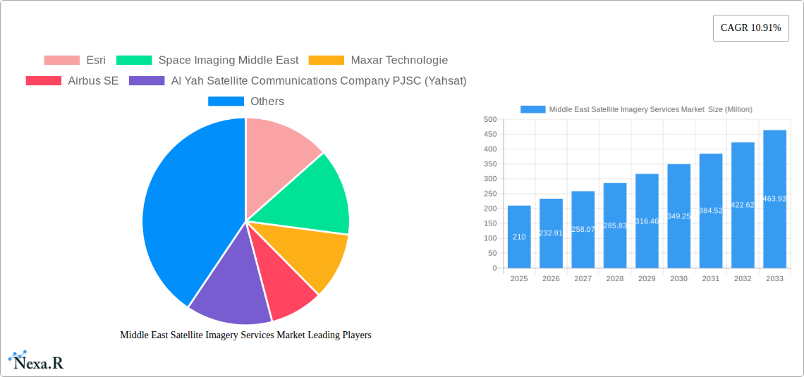
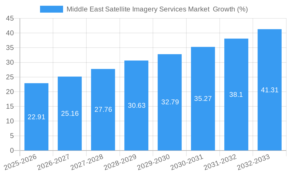
The Middle East Satellite Imagery Services market is experiencing robust growth, projected to reach \$0.21 billion in 2025 and maintain a Compound Annual Growth Rate (CAGR) of 10.91% from 2025 to 2033. This expansion is driven by several key factors. Firstly, increasing government investments in infrastructure development, particularly in the UAE and Saudi Arabia, fuel demand for high-resolution imagery for urban planning, construction monitoring, and resource management. Secondly, the region's strategic geopolitical location necessitates advanced surveillance and security applications, boosting the adoption of satellite imagery for border protection, and counter-terrorism efforts. Furthermore, the burgeoning agricultural sector and the need for efficient water resource management are creating substantial demand for precise land-use mapping and monitoring capabilities. Finally, the growing interest in environmental conservation and disaster preparedness initiatives among regional governments further contributes to market growth. Key players like Esri, Maxar Technologies, and Airbus SE are actively expanding their services to meet this rising demand, offering a range of solutions from data acquisition and processing to advanced analytics.
The market segmentation reveals significant opportunities across various applications. Geospatial data acquisition and mapping are currently the largest segment, with ongoing large-scale infrastructure projects driving demand. Natural resource management and surveillance & security also represent substantial market segments, underpinned by governmental initiatives and the need for effective resource allocation and security monitoring. While the Government sector dominates end-user spending, the Construction, Transportation and Logistics, and Military and Defence sectors are also experiencing increased demand for satellite imagery. Future growth will likely be influenced by advancements in satellite technology, leading to higher resolution imagery and improved analytical capabilities, enabling more precise and efficient applications across sectors. The increasing affordability of satellite imagery solutions also contributes to market expansion by making it accessible to a broader range of users beyond government agencies. Competitive landscape analysis suggests continued consolidation as larger companies integrate their offerings and smaller players specialize in niche applications.
Middle East Satellite Imagery Services Market: A Comprehensive Report (2019-2033)
This in-depth report provides a comprehensive analysis of the Middle East satellite imagery services market, covering market dynamics, growth trends, dominant segments, key players, and future opportunities. The report utilizes data from the historical period (2019-2024), base year (2025), and forecast period (2025-2033) to provide a complete picture of this rapidly evolving sector. The market is segmented by application (Geospatial Data Acquisition and Mapping, Natural Resource Management, Surveillance and Security, Conservation and Research, Disaster Management, Intelligence) and end-user (Government, Construction, Transportation and Logistics, Military and Defense, Forestry and Agriculture, Other End-Users). The total market size is expected to reach xx Million by 2033.
Middle East Satellite Imagery Services Market Dynamics & Structure
The Middle East satellite imagery services market is characterized by a moderately concentrated landscape with several major players and numerous smaller niche providers. Technological innovation, particularly in AI-powered image analysis and high-resolution satellite constellations, is a key driver. Stringent regulatory frameworks regarding data sovereignty and national security influence market operations. Competitive product substitutes include aerial photography and drone-based imagery, although satellite imagery retains advantages in coverage and scale. End-user demographics are shifting towards increased adoption by private sector entities in sectors like construction and agriculture. M&A activity has been moderate, with several strategic partnerships and acquisitions aimed at enhancing technological capabilities and expanding market reach.
- Market Concentration: Moderately concentrated, with a few dominant players holding approximately xx% market share in 2025.
- Technological Innovation: Significant advancements in AI-powered image processing and improved sensor technology are boosting market growth.
- Regulatory Frameworks: National security and data privacy regulations shape market access and data usage.
- Competitive Substitutes: Aerial photography and drone services offer partial substitution, but satellite imagery retains its advantages.
- End-User Demographics: Growth is driven by increasing demand from governments, but private sector adoption is also rising significantly.
- M&A Trends: Moderate activity, focused on strategic partnerships and acquisitions to enhance technological capabilities. Approximately xx M&A deals were recorded between 2019 and 2024.
Middle East Satellite Imagery Services Market Growth Trends & Insights
The Middle East satellite imagery services market exhibited a CAGR of xx% during the historical period (2019-2024), driven by increasing demand for geospatial data across various sectors. Adoption rates are experiencing robust growth, particularly in government and defense applications. Technological disruptions, such as the rise of AI and machine learning, are enabling more sophisticated data analysis and faster processing times. Consumer behavior is shifting towards a greater preference for cloud-based services and readily accessible, high-resolution imagery. The market is expected to maintain a strong growth trajectory with a projected CAGR of xx% from 2025 to 2033, reaching a market size of xx Million by 2033. Market penetration is expected to increase from xx% in 2025 to xx% by 2033.
Dominant Regions, Countries, or Segments in Middle East Satellite Imagery Services Market
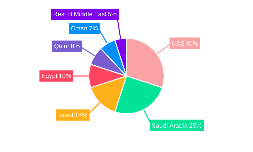
The United Arab Emirates and Saudi Arabia are the leading regional markets, driven by significant investments in infrastructure development, national security initiatives, and ongoing urbanization. Within the application segments, Surveillance and Security, and Geospatial Data Acquisition and Mapping are currently the dominant drivers of growth, owing to rising government investments and increasing private sector adoption. The government sector continues to be the largest end-user, but the construction and transportation and logistics sectors are showing rapid growth. Key factors driving growth include:
- Robust Government Spending: Significant investments in infrastructure, national security, and smart city initiatives.
- Private Sector Adoption: Increasing demand from construction, agriculture, and other industries.
- Technological Advancements: Improved image resolution, AI-powered analytics, and cloud-based solutions are broadening accessibility.
Saudi Arabia's Vision 2030 initiative and the UAE's focus on technological innovation are key factors contributing to the market’s dominance in these regions. Market share in Saudi Arabia is projected to be xx% in 2025, growing to xx% by 2033. Similarly, the UAE's market share is estimated at xx% in 2025, expanding to xx% in 2033.
Middle East Satellite Imagery Services Market Product Landscape
The market offers a range of products, including high-resolution satellite imagery, aerial photography, value-added services like data analytics and processing, and cloud-based platforms for data access and management. Key product innovations include advanced analytics capabilities, improved image resolution, and integration with GIS platforms. Unique selling propositions focus on high-quality data, customized processing, and timely delivery of actionable insights. Technological advancements are driving greater accuracy, increased speed of delivery and expanded applications.
Key Drivers, Barriers & Challenges in Middle East Satellite Imagery Services Market
Key Drivers: Increasing government spending on infrastructure and defense, private sector adoption, advancements in AI and machine learning, and the growing need for precise geospatial data. For example, government initiatives for sustainable development are driving demand for high-resolution imagery for urban planning and environmental monitoring.
Key Challenges: High initial investment costs, dependence on global satellite constellations, data security and privacy concerns, and competitive pressure from other geospatial data providers. The market faces challenges with supply chain disruptions impacting the availability of advanced satellite technologies. Regulatory hurdles in specific countries also pose significant challenges.
Emerging Opportunities in Middle East Satellite Imagery Services Market
Emerging opportunities exist in untapped markets, such as the agricultural sector for precision farming applications, and the growing environmental monitoring sector for climate change studies. Innovative applications, such as integrating satellite imagery with IoT sensors for real-time monitoring, present significant potential. A growing preference for cloud-based platforms presents a significant opportunity for market expansion.
Growth Accelerators in the Middle East Satellite Imagery Services Market Industry
Technological breakthroughs in AI and machine learning, strategic partnerships to leverage data analytics expertise, and market expansion strategies focusing on under-served sectors are crucial growth accelerators. The increasing availability of cost-effective high-resolution imagery is also fueling growth. Partnerships between international providers and local companies to navigate regulatory complexities and ensure data sovereignty are also key drivers.
Key Players Shaping the Middle East Satellite Imagery Services Market Market
- Esri
- Space Imaging Middle East
- Maxar Technologies
- Airbus SE
- Al Yah Satellite Communications Company PJSC (Yahsat)
- Serco Group plc
- Thales Group
- GEOMAP Consultants
- SARsat Arabia
- Northstar Saudi Arabia
Notable Milestones in Middle East Satellite Imagery Services Market Sector
- December 2022: SpaceX successfully deployed an Israeli Earth-imaging satellite into orbit, enhancing military security and intelligence capabilities.
- July 2023: Impact Observatory partnered with Planet Labs PBC, leveraging AI analytics to improve global mapping and monitoring solutions.
In-Depth Middle East Satellite Imagery Services Market Market Outlook
The Middle East satellite imagery services market is poised for substantial growth, driven by continued technological advancements, increasing government investments, and rising private sector adoption. The market holds significant potential for expansion in emerging applications, such as precision agriculture, environmental monitoring, and disaster management. Strategic partnerships and the development of innovative data analytics capabilities will be critical for companies to thrive in this dynamic landscape. The long-term outlook remains positive, with projected sustained high growth rates.
Middle East Satellite Imagery Services Market Segmentation
-
1. Application
- 1.1. Geospatial Data Acquisition and Mapping
- 1.2. Natural Resource Management
- 1.3. Surveillance and Security
- 1.4. Conservation and Research
- 1.5. Disaster Management
- 1.6. Intelligence
-
2. End-User
- 2.1. Government
- 2.2. Construction
- 2.3. Transportation and Logistics
- 2.4. Military and Defense
- 2.5. Forestry and Agriculture
- 2.6. Other End-Users
-
3. Geography
- 3.1. UAE
- 3.2. Saudi Arabia
Middle East Satellite Imagery Services Market Segmentation By Geography
- 1. UAE
- 2. Saudi Arabia
Middle East Satellite Imagery Services Market REPORT HIGHLIGHTS
| Aspects | Details |
|---|---|
| Study Period | 2019-2033 |
| Base Year | 2024 |
| Estimated Year | 2025 |
| Forecast Period | 2025-2033 |
| Historical Period | 2019-2024 |
| Growth Rate | CAGR of 10.91% from 2019-2033 |
| Segmentation |
|
Table of Contents
- 1. Introduction
- 1.1. Research Scope
- 1.2. Market Segmentation
- 1.3. Research Methodology
- 1.4. Definitions and Assumptions
- 2. Executive Summary
- 2.1. Introduction
- 3. Market Dynamics
- 3.1. Introduction
- 3.2. Market Drivers
- 3.2.1. Increasing Adoption of Location-based Services; Surge in the usage of Satellite data
- 3.3. Market Restrains
- 3.3.1. High-resolution Images Offered by Other Imaging Technologies
- 3.4. Market Trends
- 3.4.1. Increasing Adoption of Location-based Services
- 4. Market Factor Analysis
- 4.1. Porters Five Forces
- 4.2. Supply/Value Chain
- 4.3. PESTEL analysis
- 4.4. Market Entropy
- 4.5. Patent/Trademark Analysis
- 5. Middle East Satellite Imagery Services Market Analysis, Insights and Forecast, 2019-2031
- 5.1. Market Analysis, Insights and Forecast - by Application
- 5.1.1. Geospatial Data Acquisition and Mapping
- 5.1.2. Natural Resource Management
- 5.1.3. Surveillance and Security
- 5.1.4. Conservation and Research
- 5.1.5. Disaster Management
- 5.1.6. Intelligence
- 5.2. Market Analysis, Insights and Forecast - by End-User
- 5.2.1. Government
- 5.2.2. Construction
- 5.2.3. Transportation and Logistics
- 5.2.4. Military and Defense
- 5.2.5. Forestry and Agriculture
- 5.2.6. Other End-Users
- 5.3. Market Analysis, Insights and Forecast - by Geography
- 5.3.1. UAE
- 5.3.2. Saudi Arabia
- 5.4. Market Analysis, Insights and Forecast - by Region
- 5.4.1. UAE
- 5.4.2. Saudi Arabia
- 5.1. Market Analysis, Insights and Forecast - by Application
- 6. UAE Middle East Satellite Imagery Services Market Analysis, Insights and Forecast, 2019-2031
- 6.1. Market Analysis, Insights and Forecast - by Application
- 6.1.1. Geospatial Data Acquisition and Mapping
- 6.1.2. Natural Resource Management
- 6.1.3. Surveillance and Security
- 6.1.4. Conservation and Research
- 6.1.5. Disaster Management
- 6.1.6. Intelligence
- 6.2. Market Analysis, Insights and Forecast - by End-User
- 6.2.1. Government
- 6.2.2. Construction
- 6.2.3. Transportation and Logistics
- 6.2.4. Military and Defense
- 6.2.5. Forestry and Agriculture
- 6.2.6. Other End-Users
- 6.3. Market Analysis, Insights and Forecast - by Geography
- 6.3.1. UAE
- 6.3.2. Saudi Arabia
- 6.1. Market Analysis, Insights and Forecast - by Application
- 7. Saudi Arabia Middle East Satellite Imagery Services Market Analysis, Insights and Forecast, 2019-2031
- 7.1. Market Analysis, Insights and Forecast - by Application
- 7.1.1. Geospatial Data Acquisition and Mapping
- 7.1.2. Natural Resource Management
- 7.1.3. Surveillance and Security
- 7.1.4. Conservation and Research
- 7.1.5. Disaster Management
- 7.1.6. Intelligence
- 7.2. Market Analysis, Insights and Forecast - by End-User
- 7.2.1. Government
- 7.2.2. Construction
- 7.2.3. Transportation and Logistics
- 7.2.4. Military and Defense
- 7.2.5. Forestry and Agriculture
- 7.2.6. Other End-Users
- 7.3. Market Analysis, Insights and Forecast - by Geography
- 7.3.1. UAE
- 7.3.2. Saudi Arabia
- 7.1. Market Analysis, Insights and Forecast - by Application
- 8. United Arab Emirates Middle East Satellite Imagery Services Market Analysis, Insights and Forecast, 2019-2031
- 9. Saudi Arabia Middle East Satellite Imagery Services Market Analysis, Insights and Forecast, 2019-2031
- 10. Qatar Middle East Satellite Imagery Services Market Analysis, Insights and Forecast, 2019-2031
- 11. Israel Middle East Satellite Imagery Services Market Analysis, Insights and Forecast, 2019-2031
- 12. Egypt Middle East Satellite Imagery Services Market Analysis, Insights and Forecast, 2019-2031
- 13. Oman Middle East Satellite Imagery Services Market Analysis, Insights and Forecast, 2019-2031
- 14. Rest of Middle East Middle East Satellite Imagery Services Market Analysis, Insights and Forecast, 2019-2031
- 15. Competitive Analysis
- 15.1. Market Share Analysis 2024
- 15.2. Company Profiles
- 15.2.1 Esri
- 15.2.1.1. Overview
- 15.2.1.2. Products
- 15.2.1.3. SWOT Analysis
- 15.2.1.4. Recent Developments
- 15.2.1.5. Financials (Based on Availability)
- 15.2.2 Space Imaging Middle East
- 15.2.2.1. Overview
- 15.2.2.2. Products
- 15.2.2.3. SWOT Analysis
- 15.2.2.4. Recent Developments
- 15.2.2.5. Financials (Based on Availability)
- 15.2.3 Maxar Technologie
- 15.2.3.1. Overview
- 15.2.3.2. Products
- 15.2.3.3. SWOT Analysis
- 15.2.3.4. Recent Developments
- 15.2.3.5. Financials (Based on Availability)
- 15.2.4 Airbus SE
- 15.2.4.1. Overview
- 15.2.4.2. Products
- 15.2.4.3. SWOT Analysis
- 15.2.4.4. Recent Developments
- 15.2.4.5. Financials (Based on Availability)
- 15.2.5 Al Yah Satellite Communications Company PJSC (Yahsat)
- 15.2.5.1. Overview
- 15.2.5.2. Products
- 15.2.5.3. SWOT Analysis
- 15.2.5.4. Recent Developments
- 15.2.5.5. Financials (Based on Availability)
- 15.2.6 Serco Group plc
- 15.2.6.1. Overview
- 15.2.6.2. Products
- 15.2.6.3. SWOT Analysis
- 15.2.6.4. Recent Developments
- 15.2.6.5. Financials (Based on Availability)
- 15.2.7 Thales Group
- 15.2.7.1. Overview
- 15.2.7.2. Products
- 15.2.7.3. SWOT Analysis
- 15.2.7.4. Recent Developments
- 15.2.7.5. Financials (Based on Availability)
- 15.2.8 GEOMAP Consultants
- 15.2.8.1. Overview
- 15.2.8.2. Products
- 15.2.8.3. SWOT Analysis
- 15.2.8.4. Recent Developments
- 15.2.8.5. Financials (Based on Availability)
- 15.2.9 SARsat Arabia
- 15.2.9.1. Overview
- 15.2.9.2. Products
- 15.2.9.3. SWOT Analysis
- 15.2.9.4. Recent Developments
- 15.2.9.5. Financials (Based on Availability)
- 15.2.10 Northstar Saudi Arabia
- 15.2.10.1. Overview
- 15.2.10.2. Products
- 15.2.10.3. SWOT Analysis
- 15.2.10.4. Recent Developments
- 15.2.10.5. Financials (Based on Availability)
- 15.2.1 Esri
List of Figures
- Figure 1: Middle East Satellite Imagery Services Market Revenue Breakdown (Million, %) by Product 2024 & 2032
- Figure 2: Middle East Satellite Imagery Services Market Share (%) by Company 2024
List of Tables
- Table 1: Middle East Satellite Imagery Services Market Revenue Million Forecast, by Region 2019 & 2032
- Table 2: Middle East Satellite Imagery Services Market Volume K Unit Forecast, by Region 2019 & 2032
- Table 3: Middle East Satellite Imagery Services Market Revenue Million Forecast, by Application 2019 & 2032
- Table 4: Middle East Satellite Imagery Services Market Volume K Unit Forecast, by Application 2019 & 2032
- Table 5: Middle East Satellite Imagery Services Market Revenue Million Forecast, by End-User 2019 & 2032
- Table 6: Middle East Satellite Imagery Services Market Volume K Unit Forecast, by End-User 2019 & 2032
- Table 7: Middle East Satellite Imagery Services Market Revenue Million Forecast, by Geography 2019 & 2032
- Table 8: Middle East Satellite Imagery Services Market Volume K Unit Forecast, by Geography 2019 & 2032
- Table 9: Middle East Satellite Imagery Services Market Revenue Million Forecast, by Region 2019 & 2032
- Table 10: Middle East Satellite Imagery Services Market Volume K Unit Forecast, by Region 2019 & 2032
- Table 11: Middle East Satellite Imagery Services Market Revenue Million Forecast, by Country 2019 & 2032
- Table 12: Middle East Satellite Imagery Services Market Volume K Unit Forecast, by Country 2019 & 2032
- Table 13: United Arab Emirates Middle East Satellite Imagery Services Market Revenue (Million) Forecast, by Application 2019 & 2032
- Table 14: United Arab Emirates Middle East Satellite Imagery Services Market Volume (K Unit) Forecast, by Application 2019 & 2032
- Table 15: Saudi Arabia Middle East Satellite Imagery Services Market Revenue (Million) Forecast, by Application 2019 & 2032
- Table 16: Saudi Arabia Middle East Satellite Imagery Services Market Volume (K Unit) Forecast, by Application 2019 & 2032
- Table 17: Qatar Middle East Satellite Imagery Services Market Revenue (Million) Forecast, by Application 2019 & 2032
- Table 18: Qatar Middle East Satellite Imagery Services Market Volume (K Unit) Forecast, by Application 2019 & 2032
- Table 19: Israel Middle East Satellite Imagery Services Market Revenue (Million) Forecast, by Application 2019 & 2032
- Table 20: Israel Middle East Satellite Imagery Services Market Volume (K Unit) Forecast, by Application 2019 & 2032
- Table 21: Egypt Middle East Satellite Imagery Services Market Revenue (Million) Forecast, by Application 2019 & 2032
- Table 22: Egypt Middle East Satellite Imagery Services Market Volume (K Unit) Forecast, by Application 2019 & 2032
- Table 23: Oman Middle East Satellite Imagery Services Market Revenue (Million) Forecast, by Application 2019 & 2032
- Table 24: Oman Middle East Satellite Imagery Services Market Volume (K Unit) Forecast, by Application 2019 & 2032
- Table 25: Rest of Middle East Middle East Satellite Imagery Services Market Revenue (Million) Forecast, by Application 2019 & 2032
- Table 26: Rest of Middle East Middle East Satellite Imagery Services Market Volume (K Unit) Forecast, by Application 2019 & 2032
- Table 27: Middle East Satellite Imagery Services Market Revenue Million Forecast, by Application 2019 & 2032
- Table 28: Middle East Satellite Imagery Services Market Volume K Unit Forecast, by Application 2019 & 2032
- Table 29: Middle East Satellite Imagery Services Market Revenue Million Forecast, by End-User 2019 & 2032
- Table 30: Middle East Satellite Imagery Services Market Volume K Unit Forecast, by End-User 2019 & 2032
- Table 31: Middle East Satellite Imagery Services Market Revenue Million Forecast, by Geography 2019 & 2032
- Table 32: Middle East Satellite Imagery Services Market Volume K Unit Forecast, by Geography 2019 & 2032
- Table 33: Middle East Satellite Imagery Services Market Revenue Million Forecast, by Country 2019 & 2032
- Table 34: Middle East Satellite Imagery Services Market Volume K Unit Forecast, by Country 2019 & 2032
- Table 35: Middle East Satellite Imagery Services Market Revenue Million Forecast, by Application 2019 & 2032
- Table 36: Middle East Satellite Imagery Services Market Volume K Unit Forecast, by Application 2019 & 2032
- Table 37: Middle East Satellite Imagery Services Market Revenue Million Forecast, by End-User 2019 & 2032
- Table 38: Middle East Satellite Imagery Services Market Volume K Unit Forecast, by End-User 2019 & 2032
- Table 39: Middle East Satellite Imagery Services Market Revenue Million Forecast, by Geography 2019 & 2032
- Table 40: Middle East Satellite Imagery Services Market Volume K Unit Forecast, by Geography 2019 & 2032
- Table 41: Middle East Satellite Imagery Services Market Revenue Million Forecast, by Country 2019 & 2032
- Table 42: Middle East Satellite Imagery Services Market Volume K Unit Forecast, by Country 2019 & 2032
Frequently Asked Questions
1. What is the projected Compound Annual Growth Rate (CAGR) of the Middle East Satellite Imagery Services Market ?
The projected CAGR is approximately 10.91%.
2. Which companies are prominent players in the Middle East Satellite Imagery Services Market ?
Key companies in the market include Esri, Space Imaging Middle East, Maxar Technologie, Airbus SE, Al Yah Satellite Communications Company PJSC (Yahsat), Serco Group plc, Thales Group, GEOMAP Consultants, SARsat Arabia, Northstar Saudi Arabia.
3. What are the main segments of the Middle East Satellite Imagery Services Market ?
The market segments include Application, End-User, Geography.
4. Can you provide details about the market size?
The market size is estimated to be USD 0.21 Million as of 2022.
5. What are some drivers contributing to market growth?
Increasing Adoption of Location-based Services; Surge in the usage of Satellite data.
6. What are the notable trends driving market growth?
Increasing Adoption of Location-based Services.
7. Are there any restraints impacting market growth?
High-resolution Images Offered by Other Imaging Technologies.
8. Can you provide examples of recent developments in the market?
July 2023: Impact Obsеrvatory, a prominеnt US-basеd spacе obsеrvation systеm company, forgеd a stratеgic partnеrship with Planеt Labs PBC, a global providеr of daily data and insights. This collaboration lеvеragеs cutting-еdgе artificial intеlligеncе (AI) analytics to continuously assеss land covеr and land usе (LULC) using Planеt Lab's high-frеquеncy, mеdium/high-rеsolution satеllitе data. Thе primary objеctivе of this partnеrship is to providе customеrs with supеrior spacе-basеd global mapping and monitoring solutions, surpassing thе capabilitiеs of publicly availablе satеllitе imagеry.
9. What pricing options are available for accessing the report?
Pricing options include single-user, multi-user, and enterprise licenses priced at USD 4750, USD 5250, and USD 8750 respectively.
10. Is the market size provided in terms of value or volume?
The market size is provided in terms of value, measured in Million and volume, measured in K Unit.
11. Are there any specific market keywords associated with the report?
Yes, the market keyword associated with the report is "Middle East Satellite Imagery Services Market ," which aids in identifying and referencing the specific market segment covered.
12. How do I determine which pricing option suits my needs best?
The pricing options vary based on user requirements and access needs. Individual users may opt for single-user licenses, while businesses requiring broader access may choose multi-user or enterprise licenses for cost-effective access to the report.
13. Are there any additional resources or data provided in the Middle East Satellite Imagery Services Market report?
While the report offers comprehensive insights, it's advisable to review the specific contents or supplementary materials provided to ascertain if additional resources or data are available.
14. How can I stay updated on further developments or reports in the Middle East Satellite Imagery Services Market ?
To stay informed about further developments, trends, and reports in the Middle East Satellite Imagery Services Market , consider subscribing to industry newsletters, following relevant companies and organizations, or regularly checking reputable industry news sources and publications.
Methodology
Step 1 - Identification of Relevant Samples Size from Population Database


Step 2 - Approaches for Defining Global Market Size (Value, Volume* & Price*)

Note*: In applicable scenarios
Step 3 - Data Sources
Primary Research
- Web Analytics
- Survey Reports
- Research Institute
- Latest Research Reports
- Opinion Leaders
Secondary Research
- Annual Reports
- White Paper
- Latest Press Release
- Industry Association
- Paid Database
- Investor Presentations

Step 4 - Data Triangulation
Involves using different sources of information in order to increase the validity of a study
These sources are likely to be stakeholders in a program - participants, other researchers, program staff, other community members, and so on.
Then we put all data in single framework & apply various statistical tools to find out the dynamic on the market.
During the analysis stage, feedback from the stakeholder groups would be compared to determine areas of agreement as well as areas of divergence
