

Key Insights
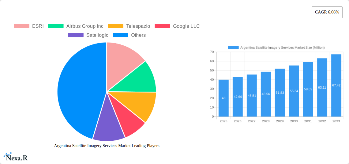
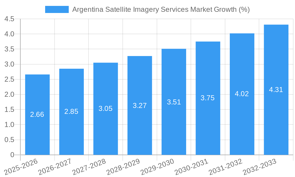
The Argentina Satellite Imagery Services market, valued at $40 million in 2025, is projected to experience robust growth, driven by increasing government investments in infrastructure development, particularly in geospatial mapping for urban planning and resource management. The market's Compound Annual Growth Rate (CAGR) of 6.66% from 2025 to 2033 reflects a steady demand for high-resolution imagery across diverse sectors. Key application areas include geospatial data acquisition and mapping, crucial for efficient urban planning and infrastructure development in Argentina. Natural resource management, leveraging satellite imagery for precise land use monitoring and environmental protection initiatives, also contributes significantly. Furthermore, the burgeoning surveillance and security sector relies heavily on satellite imagery for border control, crime prevention, and disaster response. Growth is further fueled by the adoption of advanced analytics and AI-powered image processing techniques, enabling more efficient data extraction and interpretation. The government sector remains the largest end-user, followed by the construction, transportation, and logistics industries, all demanding precise and up-to-date geographical information for efficient operations and decision-making.
While the market faces constraints such as the high initial investment costs associated with satellite technology and data acquisition, these are being mitigated by the increasing affordability of satellite imagery and the emergence of cloud-based platforms providing efficient data storage and processing. The presence of established players like ESRI, Airbus, and Google, along with emerging local companies, fosters a competitive landscape, stimulating innovation and driving down costs. The market's future growth hinges on continued government support, the adoption of advanced technologies, and the increasing awareness of the benefits of satellite imagery across various sectors. Focus areas for future growth will likely include the integration of satellite imagery with other data sources to create comprehensive geographical information systems (GIS) and the utilization of advanced analytics for predictive modeling and risk assessment. The expansion of high-speed internet infrastructure will also be key to facilitating wider accessibility and utilization of satellite imagery data.
Argentina Satellite Imagery Services Market: A Comprehensive Report (2019-2033)
This comprehensive report provides an in-depth analysis of the Argentina Satellite Imagery Services Market, offering valuable insights for industry professionals, investors, and strategic decision-makers. The report covers the period from 2019 to 2033, with a focus on the 2025-2033 forecast period. The market is segmented by application (Geospatial Data Acquisition and Mapping, Natural Resource Management, Surveillance and Security, Conservation and Research, Disaster Management, Intelligence) and end-user (Government, Construction, Transportation and Logistics, Military and Defense, Forestry and Agriculture, Others). Key players analyzed include ESRI, Airbus Group Inc, Telespazio, Google LLC, Satellogic, L3 Harris corporation, Dymaxion Labs, and Galileo Group. The market size is presented in million units.
Argentina Satellite Imagery Services Market Dynamics & Structure
The Argentina satellite imagery services market exhibits a moderately concentrated structure, with a few dominant players alongside several smaller, specialized firms. Technological innovation, particularly in high-resolution imagery and AI-powered analytics, is a key driver. Regulatory frameworks concerning data privacy and national security influence market operations. While traditional aerial photography presents some competition, the superior capabilities of satellite imagery, particularly for large-scale projects, ensure its continued dominance. End-user demographics are diverse, with strong demand across government, defense, and resource management sectors. M&A activity has been relatively limited in recent years (xx deals between 2019-2024), reflecting the specialized nature of the market.
- Market Concentration: Moderately concentrated, with a Herfindahl-Hirschman Index (HHI) of xx in 2025.
- Technological Innovation: Driven by advancements in sensor technology, data processing, and AI-based analytics.
- Regulatory Framework: Subject to national security and data privacy regulations.
- Competitive Substitutes: Primarily aerial photography, but satellite imagery offers superior coverage and resolution.
- End-User Demographics: Government, defense, and resource management sectors are major consumers.
- M&A Trends: Relatively low M&A activity (xx deals) between 2019-2024; potential for increased consolidation in the coming years.
Argentina Satellite Imagery Services Market Growth Trends & Insights
The Argentina satellite imagery services market has witnessed significant growth over the historical period (2019-2024), driven by increasing demand across various sectors and technological advancements. The market size is estimated at XX million in 2025 and is projected to reach XX million by 2033, exhibiting a CAGR of xx% during the forecast period (2025-2033). This growth is fueled by factors such as rising government investment in infrastructure projects, increased adoption of precision agriculture techniques, and the growing need for effective disaster management tools. The market penetration rate for satellite imagery services is steadily increasing, particularly in sectors such as agriculture and urban planning. Technological disruptions, including the rise of small satellite constellations and improved data analytics capabilities, are further accelerating market expansion. Consumer behavior is shifting towards cloud-based solutions and data-as-a-service models.
Dominant Regions, Countries, or Segments in Argentina Satellite Imagery Services Market
The Government sector holds the largest market share in the Argentina satellite imagery services market in 2025, driven by robust spending on defense and national security initiatives. The Geospatial Data Acquisition and Mapping application segment is the leading application, owing to significant demand for precise and up-to-date maps for infrastructure development and urban planning. Buenos Aires province and other major urban centers exhibit the strongest regional growth, fueled by high levels of construction and urban development.
- Key Drivers for Government Sector: National security, border surveillance, infrastructure development, disaster management, and resource management.
- Key Drivers for Geospatial Data Acquisition and Mapping: Urban planning, infrastructure development, precision agriculture.
- Dominance Factors: Government policy, favorable regulatory environment, and investment in infrastructure projects.
- Growth Potential: Strong potential for growth driven by increasing demand for high-resolution imagery and advanced analytics.
Argentina Satellite Imagery Services Market Product Landscape
The market offers a range of satellite imagery products, from high-resolution panchromatic and multispectral imagery to advanced hyperspectral and SAR data. Products are differentiated by resolution, spatial coverage, temporal frequency, and data processing capabilities. Unique selling propositions include improved accuracy, rapid data delivery, and value-added services such as geospatial analytics and customized data visualization. Technological advancements are focused on enhancing resolution, improving data accuracy, and increasing processing speeds.
Key Drivers, Barriers & Challenges in Argentina Satellite Imagery Services Market
Key Drivers:
- Increasing government investment in infrastructure and defense.
- Growing adoption of precision agriculture techniques.
- Demand for effective disaster management tools.
- Technological advancements in satellite imagery and data analytics.
Key Challenges:
- High cost of satellite imagery and data processing.
- Data privacy and security concerns.
- Lack of awareness among some end-users about the benefits of satellite imagery.
- Competition from traditional aerial photography. The overall impact of these challenges on market growth is estimated at xx% reduction in potential growth.
Emerging Opportunities in Argentina Satellite Imagery Services Market
- Growing demand for environmental monitoring and conservation efforts.
- Expanding use of satellite imagery in the agriculture sector for yield optimization and precision farming.
- Increasing adoption of cloud-based satellite imagery platforms.
- Development of AI-powered analytics tools for enhanced data interpretation and decision-making.
Growth Accelerators in the Argentina Satellite Imagery Services Market Industry
Technological innovation, particularly the development of higher-resolution sensors and advanced analytics capabilities, is a primary catalyst for market growth. Strategic partnerships between satellite operators, data analytics firms, and end-users are fostering market expansion. Government initiatives promoting the use of geospatial data in various sectors further accelerate adoption. The expansion into untapped market segments, such as environmental monitoring and precision agriculture, presents significant growth opportunities.
Key Players Shaping the Argentina Satellite Imagery Services Market Market
- ESRI
- Airbus Group Inc
- Telespazio
- Google LLC
- Satellogic
- L3 Harris corporation
- Dymaxion Labs
- Galileo Group
Notable Milestones in Argentina Satellite Imagery Services Market Sector
- 2020: Launch of a new high-resolution satellite by a local provider.
- 2022: Government initiative to promote the use of satellite imagery for urban planning.
- 2023: Partnership between a major satellite operator and a local agricultural company to implement precision farming techniques.
In-Depth Argentina Satellite Imagery Services Market Market Outlook
The Argentina satellite imagery services market is poised for continued strong growth over the forecast period (2025-2033). Technological advancements, increasing government investment, and expanding applications across various sectors will drive market expansion. Opportunities exist in emerging sectors such as environmental monitoring and precision agriculture, along with the adoption of innovative data analytics techniques. Strategic partnerships and investments in infrastructure will further fuel market growth, presenting lucrative opportunities for both established players and new entrants.
Argentina Satellite Imagery Services Market Segmentation
-
1. Application
- 1.1. Geospatial Data Acquisition and Mapping
- 1.2. Natural Resource Management
- 1.3. Surveillance and Security
- 1.4. Conservation and Research
- 1.5. Disaster Management
- 1.6. Intelligence
-
2. End-User
- 2.1. Government
- 2.2. Construction
- 2.3. Transportation and Logistics
- 2.4. Military and Defense
- 2.5. Forestry and Agriculture
- 2.6. Others
Argentina Satellite Imagery Services Market Segmentation By Geography
- 1. Argentina
Argentina Satellite Imagery Services Market REPORT HIGHLIGHTS
| Aspects | Details |
|---|---|
| Study Period | 2019-2033 |
| Base Year | 2024 |
| Estimated Year | 2025 |
| Forecast Period | 2025-2033 |
| Historical Period | 2019-2024 |
| Growth Rate | CAGR of 6.66% from 2019-2033 |
| Segmentation |
|
Table of Contents
- 1. Introduction
- 1.1. Research Scope
- 1.2. Market Segmentation
- 1.3. Research Methodology
- 1.4. Definitions and Assumptions
- 2. Executive Summary
- 2.1. Introduction
- 3. Market Dynamics
- 3.1. Introduction
- 3.2. Market Drivers
- 3.2.1. Increasing Adoption of Location-based Services; Satellite data usage is increasing
- 3.3. Market Restrains
- 3.3.1. Strict government regulations; High-resolution Images Offered by Other Imaging Technologies
- 3.4. Market Trends
- 3.4.1. Natural Resource Management is Expected to Significant Share
- 4. Market Factor Analysis
- 4.1. Porters Five Forces
- 4.2. Supply/Value Chain
- 4.3. PESTEL analysis
- 4.4. Market Entropy
- 4.5. Patent/Trademark Analysis
- 5. Argentina Satellite Imagery Services Market Analysis, Insights and Forecast, 2019-2031
- 5.1. Market Analysis, Insights and Forecast - by Application
- 5.1.1. Geospatial Data Acquisition and Mapping
- 5.1.2. Natural Resource Management
- 5.1.3. Surveillance and Security
- 5.1.4. Conservation and Research
- 5.1.5. Disaster Management
- 5.1.6. Intelligence
- 5.2. Market Analysis, Insights and Forecast - by End-User
- 5.2.1. Government
- 5.2.2. Construction
- 5.2.3. Transportation and Logistics
- 5.2.4. Military and Defense
- 5.2.5. Forestry and Agriculture
- 5.2.6. Others
- 5.3. Market Analysis, Insights and Forecast - by Region
- 5.3.1. Argentina
- 5.1. Market Analysis, Insights and Forecast - by Application
- 6. Competitive Analysis
- 6.1. Market Share Analysis 2024
- 6.2. Company Profiles
- 6.2.1 ESRI
- 6.2.1.1. Overview
- 6.2.1.2. Products
- 6.2.1.3. SWOT Analysis
- 6.2.1.4. Recent Developments
- 6.2.1.5. Financials (Based on Availability)
- 6.2.2 Airbus Group Inc
- 6.2.2.1. Overview
- 6.2.2.2. Products
- 6.2.2.3. SWOT Analysis
- 6.2.2.4. Recent Developments
- 6.2.2.5. Financials (Based on Availability)
- 6.2.3 Telespazio
- 6.2.3.1. Overview
- 6.2.3.2. Products
- 6.2.3.3. SWOT Analysis
- 6.2.3.4. Recent Developments
- 6.2.3.5. Financials (Based on Availability)
- 6.2.4 Google LLC
- 6.2.4.1. Overview
- 6.2.4.2. Products
- 6.2.4.3. SWOT Analysis
- 6.2.4.4. Recent Developments
- 6.2.4.5. Financials (Based on Availability)
- 6.2.5 Satellogic
- 6.2.5.1. Overview
- 6.2.5.2. Products
- 6.2.5.3. SWOT Analysis
- 6.2.5.4. Recent Developments
- 6.2.5.5. Financials (Based on Availability)
- 6.2.6 L3 Harris corporation
- 6.2.6.1. Overview
- 6.2.6.2. Products
- 6.2.6.3. SWOT Analysis
- 6.2.6.4. Recent Developments
- 6.2.6.5. Financials (Based on Availability)
- 6.2.7 Dymaxion Labs
- 6.2.7.1. Overview
- 6.2.7.2. Products
- 6.2.7.3. SWOT Analysis
- 6.2.7.4. Recent Developments
- 6.2.7.5. Financials (Based on Availability)
- 6.2.8 Gallileo Group
- 6.2.8.1. Overview
- 6.2.8.2. Products
- 6.2.8.3. SWOT Analysis
- 6.2.8.4. Recent Developments
- 6.2.8.5. Financials (Based on Availability)
- 6.2.1 ESRI
List of Figures
- Figure 1: Argentina Satellite Imagery Services Market Revenue Breakdown (Million, %) by Product 2024 & 2032
- Figure 2: Argentina Satellite Imagery Services Market Share (%) by Company 2024
List of Tables
- Table 1: Argentina Satellite Imagery Services Market Revenue Million Forecast, by Region 2019 & 2032
- Table 2: Argentina Satellite Imagery Services Market Revenue Million Forecast, by Application 2019 & 2032
- Table 3: Argentina Satellite Imagery Services Market Revenue Million Forecast, by End-User 2019 & 2032
- Table 4: Argentina Satellite Imagery Services Market Revenue Million Forecast, by Region 2019 & 2032
- Table 5: Argentina Satellite Imagery Services Market Revenue Million Forecast, by Country 2019 & 2032
- Table 6: Argentina Satellite Imagery Services Market Revenue Million Forecast, by Application 2019 & 2032
- Table 7: Argentina Satellite Imagery Services Market Revenue Million Forecast, by End-User 2019 & 2032
- Table 8: Argentina Satellite Imagery Services Market Revenue Million Forecast, by Country 2019 & 2032
Frequently Asked Questions
1. What is the projected Compound Annual Growth Rate (CAGR) of the Argentina Satellite Imagery Services Market?
The projected CAGR is approximately 6.66%.
2. Which companies are prominent players in the Argentina Satellite Imagery Services Market?
Key companies in the market include ESRI, Airbus Group Inc, Telespazio, Google LLC, Satellogic, L3 Harris corporation, Dymaxion Labs, Gallileo Group.
3. What are the main segments of the Argentina Satellite Imagery Services Market?
The market segments include Application, End-User.
4. Can you provide details about the market size?
The market size is estimated to be USD 0.04 Million as of 2022.
5. What are some drivers contributing to market growth?
Increasing Adoption of Location-based Services; Satellite data usage is increasing.
6. What are the notable trends driving market growth?
Natural Resource Management is Expected to Significant Share.
7. Are there any restraints impacting market growth?
Strict government regulations; High-resolution Images Offered by Other Imaging Technologies.
8. Can you provide examples of recent developments in the market?
N/A
9. What pricing options are available for accessing the report?
Pricing options include single-user, multi-user, and enterprise licenses priced at USD 3800, USD 4500, and USD 5800 respectively.
10. Is the market size provided in terms of value or volume?
The market size is provided in terms of value, measured in Million.
11. Are there any specific market keywords associated with the report?
Yes, the market keyword associated with the report is "Argentina Satellite Imagery Services Market," which aids in identifying and referencing the specific market segment covered.
12. How do I determine which pricing option suits my needs best?
The pricing options vary based on user requirements and access needs. Individual users may opt for single-user licenses, while businesses requiring broader access may choose multi-user or enterprise licenses for cost-effective access to the report.
13. Are there any additional resources or data provided in the Argentina Satellite Imagery Services Market report?
While the report offers comprehensive insights, it's advisable to review the specific contents or supplementary materials provided to ascertain if additional resources or data are available.
14. How can I stay updated on further developments or reports in the Argentina Satellite Imagery Services Market?
To stay informed about further developments, trends, and reports in the Argentina Satellite Imagery Services Market, consider subscribing to industry newsletters, following relevant companies and organizations, or regularly checking reputable industry news sources and publications.
Methodology
Step 1 - Identification of Relevant Samples Size from Population Database


Step 2 - Approaches for Defining Global Market Size (Value, Volume* & Price*)

Note*: In applicable scenarios
Step 3 - Data Sources
Primary Research
- Web Analytics
- Survey Reports
- Research Institute
- Latest Research Reports
- Opinion Leaders
Secondary Research
- Annual Reports
- White Paper
- Latest Press Release
- Industry Association
- Paid Database
- Investor Presentations

Step 4 - Data Triangulation
Involves using different sources of information in order to increase the validity of a study
These sources are likely to be stakeholders in a program - participants, other researchers, program staff, other community members, and so on.
Then we put all data in single framework & apply various statistical tools to find out the dynamic on the market.
During the analysis stage, feedback from the stakeholder groups would be compared to determine areas of agreement as well as areas of divergence
