

Key Insights
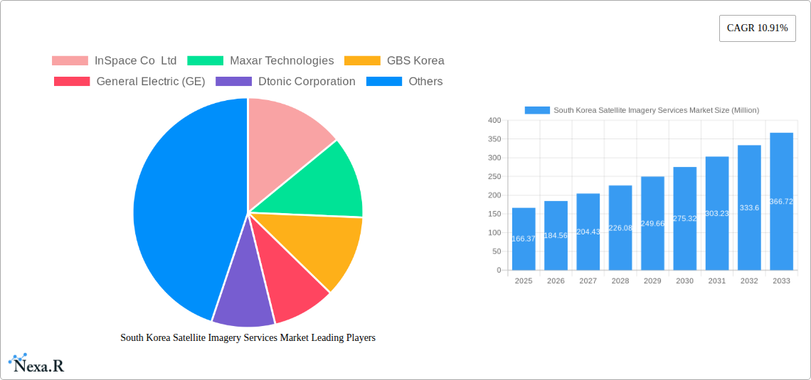
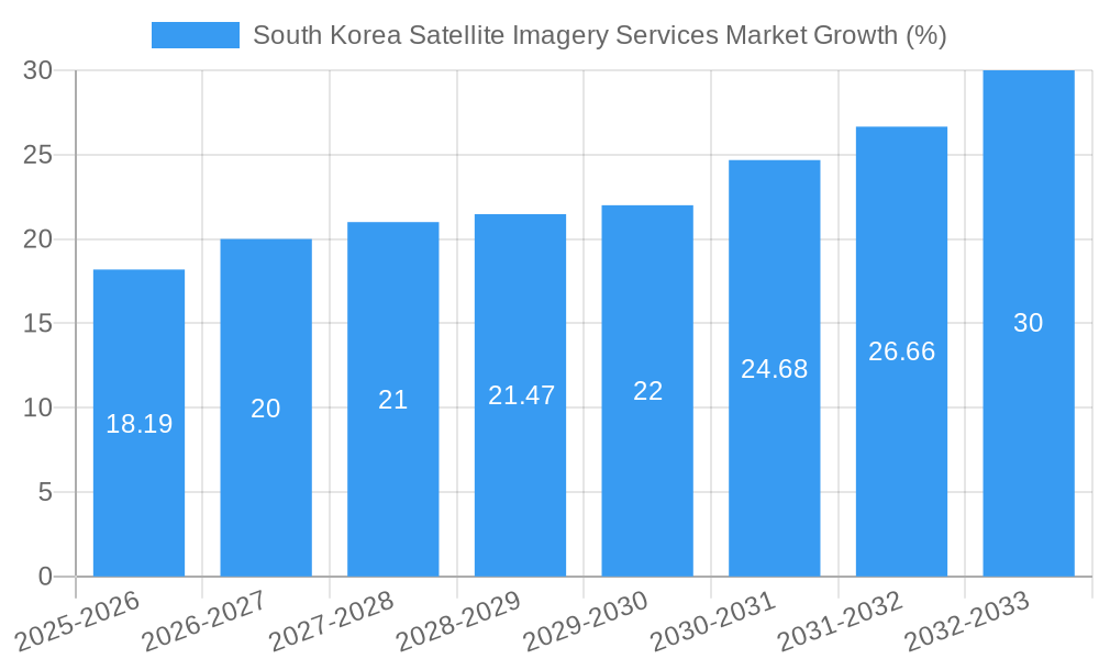
The South Korean satellite imagery services market, valued at $166.37 million in 2025, is projected to experience robust growth, driven by increasing government investments in infrastructure development, national security initiatives, and precision agriculture. The market's Compound Annual Growth Rate (CAGR) of 10.91% from 2025 to 2033 indicates significant expansion opportunities. Key application segments include geospatial data acquisition and mapping for urban planning and infrastructure projects, natural resource management for efficient land utilization and environmental monitoring, and surveillance and security applications for enhanced public safety. The strong presence of government and military end-users fuels this growth, alongside the increasing adoption of satellite imagery in the construction, transportation, and agriculture sectors. While data privacy concerns and high initial investment costs might pose challenges, technological advancements in high-resolution imagery and improved data analytics are expected to overcome these hurdles, fostering market expansion.
The market's segmentation reveals a diverse landscape. The government sector dominates the end-user segment, reflecting the strategic importance of satellite imagery for national security and infrastructure management. Within applications, geospatial data acquisition and mapping is a leading segment, spurred by the need for precise and up-to-date geographical information. The rising demand for efficient resource management, particularly in agriculture and forestry, is another significant driver. The presence of established players like Maxar Technologies and ESRI Inc., alongside innovative local companies like InSpace Co Ltd and Dabeeo Inc, indicates a competitive yet dynamic market environment. Future growth will likely be influenced by advancements in AI-powered image analysis, improved accessibility of satellite data, and further government support for technological development in this sector.
South Korea Satellite Imagery Services Market: A Comprehensive Report (2019-2033)
This comprehensive report provides an in-depth analysis of the South Korea Satellite Imagery Services Market, encompassing market dynamics, growth trends, key players, and future outlook. The study period spans from 2019 to 2033, with 2025 serving as the base and estimated year. This report is essential for businesses, investors, and researchers seeking to understand and capitalize on opportunities within this dynamic sector. The parent market is the broader Geospatial Intelligence market, while the child market is specifically the South Korean Satellite Imagery Services segment. The market size is projected to reach xx Million by 2033.
South Korea Satellite Imagery Services Market Dynamics & Structure
The South Korean satellite imagery services market exhibits a moderately concentrated structure, with a few dominant players alongside several smaller, specialized firms. Technological innovation, particularly in AI-powered image analysis and high-resolution satellite imagery, is a key driver. The regulatory framework, including data privacy laws and government policies promoting technological advancement, significantly influences market growth. Competitive product substitutes, such as aerial photography and LiDAR, exert some pressure, though satellite imagery offers unique advantages in terms of coverage and frequency. End-user demographics are diverse, encompassing government agencies, the military, construction firms, and agricultural businesses.
- Market Concentration: Moderately concentrated, with top 5 players holding approximately xx% market share in 2025.
- Technological Innovation: Significant advancements in sensor technology, AI-driven image processing, and cloud-based data management are driving growth.
- Regulatory Landscape: Government initiatives supporting digital transformation and data infrastructure development are creating favorable conditions.
- Competitive Substitutes: Aerial photography and LiDAR pose some competition, but satellite imagery offers unique advantages in scale and repeatability.
- M&A Activity: A moderate number of M&A transactions are observed, driven by strategic expansion and technological integration. Approximately xx M&A deals were recorded between 2019 and 2024.
- Innovation Barriers: High initial investment costs for satellite technology and data processing infrastructure, along with limited skilled workforce availability, pose challenges.
South Korea Satellite Imagery Services Market Growth Trends & Insights
The South Korea satellite imagery services market has witnessed robust growth over the historical period (2019-2024), driven by increasing demand across various sectors. The market size expanded from xx Million in 2019 to xx Million in 2024, exhibiting a CAGR of xx%. This growth is projected to continue into the forecast period (2025-2033), with a projected CAGR of xx%, reaching xx Million by 2033. The adoption rate of satellite imagery services is rising steadily, particularly within government and defense sectors. Technological disruptions, such as the integration of AI and machine learning for enhanced image analysis, are accelerating market expansion. Consumer behavior shifts are also observed, with increased preference for cloud-based data access and on-demand services.
Dominant Regions, Countries, or Segments in South Korea Satellite Imagery Services Market
The South Korean satellite imagery services market exhibits strong growth across multiple segments. The Government sector is a dominant end-user, leveraging satellite imagery for urban planning, national security, and disaster management. The Geospatial Data Acquisition and Mapping application segment exhibits the highest growth potential, propelled by increasing needs for precise and updated map data. Seoul and other major metropolitan areas represent crucial regional markets due to high infrastructure development and urban planning activities.
- Dominant End-User: Government (xx% market share in 2025), driven by national security and infrastructure development needs.
- Fastest-Growing Application: Geospatial Data Acquisition and Mapping, fueled by demand for high-precision mapping and 3D modeling.
- Key Regional Markets: Seoul, Busan, Daegu, and other major urban centers, experiencing significant growth due to urban expansion and construction projects.
- Growth Drivers: Government investments in infrastructure projects, increasing urbanization, and rising demand for accurate geospatial data are key growth catalysts.
South Korea Satellite Imagery Services Market Product Landscape
The South Korea satellite imagery services market offers a range of products, including high-resolution panchromatic and multispectral imagery, hyperspectral imaging, and advanced analytics tools. These products cater to diverse applications, from precision agriculture to infrastructure monitoring and defense applications. Key product innovations include improved sensor technology offering greater spatial resolution and enhanced spectral capabilities, alongside AI-powered analytics tools enabling efficient extraction of valuable information from imagery data.
Key Drivers, Barriers & Challenges in South Korea Satellite Imagery Services Market
Key Drivers: Increased government investment in infrastructure and digitalization, rising demand for accurate geospatial data, technological advancements, and the growing need for security and surveillance solutions fuel market expansion.
Challenges: High initial investment costs associated with satellite technology, dependence on imported technology, and potential data privacy concerns pose challenges to market growth. Competition from established global players presents a significant hurdle for domestic companies. Supply chain disruptions can impact the availability of crucial hardware and software components.
Emerging Opportunities in South Korea Satellite Imagery Services Market
Untapped potential exists in the application of satellite imagery for precision agriculture, environmental monitoring, and smart city initiatives. The increasing adoption of AI and machine learning in image processing opens new opportunities for automated analysis and insights extraction. The development of innovative applications for disaster response and emergency management represents a significant opportunity.
Growth Accelerators in the South Korea Satellite Imagery Services Market Industry
Strategic partnerships and collaborations between domestic and international players, as seen in Dabeeo’s partnership with Maxar, are driving innovation and market penetration. Technological advancements, particularly in AI-powered image analysis, are further accelerating market expansion. Government initiatives supporting technology development and promoting the adoption of satellite imagery services are crucial for long-term market growth.
Key Players Shaping the South Korea Satellite Imagery Services Market Market
- InSpace Co Ltd
- Maxar Technologies
- GBS Korea
- General Electric (GE)
- Dtonic Corporation
- ESRI Inc
- L3Harris Corporation Inc
- Soletop
- Bentley Systems Inc
- Dabeeo Inc
Notable Milestones in South Korea Satellite Imagery Services Market Sector
- November 2022: Dabeeo partners with Maxar Technologies, expanding its imaging services and market reach.
- August 2022: Yahaha launches an AI-powered mirror world project using Dabeeo’s geospatial data and satellite imagery technology.
In-Depth South Korea Satellite Imagery Services Market Market Outlook
The South Korea satellite imagery services market is poised for continued growth, driven by technological advancements, increasing government investments, and the expanding applications of satellite imagery across various sectors. Strategic partnerships, focusing on innovation and market expansion, will play a crucial role in shaping future market dynamics. The integration of AI and the development of novel applications will create significant opportunities for market participants. The market's future potential is substantial, and strategic players are well-positioned to capitalize on this growth.
South Korea Satellite Imagery Services Market Segmentation
-
1. Application
- 1.1. Geospatial Data Acquisition and Mapping
- 1.2. Natural Resource Management
- 1.3. Surveillance and Security
- 1.4. Conservation and Research
- 1.5. Disaster Management
- 1.6. Intelligence
-
2. End-User
- 2.1. Government
- 2.2. Construction
- 2.3. Transportation and Logistics
- 2.4. Military and Defense
- 2.5. Forestry and Agriculture
- 2.6. Others
South Korea Satellite Imagery Services Market Segmentation By Geography
- 1. South Korea
South Korea Satellite Imagery Services Market REPORT HIGHLIGHTS
| Aspects | Details |
|---|---|
| Study Period | 2019-2033 |
| Base Year | 2024 |
| Estimated Year | 2025 |
| Forecast Period | 2025-2033 |
| Historical Period | 2019-2024 |
| Growth Rate | CAGR of 10.91% from 2019-2033 |
| Segmentation |
|
Table of Contents
- 1. Introduction
- 1.1. Research Scope
- 1.2. Market Segmentation
- 1.3. Research Methodology
- 1.4. Definitions and Assumptions
- 2. Executive Summary
- 2.1. Introduction
- 3. Market Dynamics
- 3.1. Introduction
- 3.2. Market Drivers
- 3.2.1. Growing requirement of Security System in South Korea; Rising Smart City Initiatives
- 3.3. Market Restrains
- 3.3.1. Budget Constraints and Technological Limitations
- 3.4. Market Trends
- 3.4.1. Growing Use of Satellite Imagery Services in Military and Defense Sector
- 4. Market Factor Analysis
- 4.1. Porters Five Forces
- 4.2. Supply/Value Chain
- 4.3. PESTEL analysis
- 4.4. Market Entropy
- 4.5. Patent/Trademark Analysis
- 5. South Korea Satellite Imagery Services Market Analysis, Insights and Forecast, 2019-2031
- 5.1. Market Analysis, Insights and Forecast - by Application
- 5.1.1. Geospatial Data Acquisition and Mapping
- 5.1.2. Natural Resource Management
- 5.1.3. Surveillance and Security
- 5.1.4. Conservation and Research
- 5.1.5. Disaster Management
- 5.1.6. Intelligence
- 5.2. Market Analysis, Insights and Forecast - by End-User
- 5.2.1. Government
- 5.2.2. Construction
- 5.2.3. Transportation and Logistics
- 5.2.4. Military and Defense
- 5.2.5. Forestry and Agriculture
- 5.2.6. Others
- 5.3. Market Analysis, Insights and Forecast - by Region
- 5.3.1. South Korea
- 5.1. Market Analysis, Insights and Forecast - by Application
- 6. Competitive Analysis
- 6.1. Market Share Analysis 2024
- 6.2. Company Profiles
- 6.2.1 InSpace Co Ltd
- 6.2.1.1. Overview
- 6.2.1.2. Products
- 6.2.1.3. SWOT Analysis
- 6.2.1.4. Recent Developments
- 6.2.1.5. Financials (Based on Availability)
- 6.2.2 Maxar Technologies
- 6.2.2.1. Overview
- 6.2.2.2. Products
- 6.2.2.3. SWOT Analysis
- 6.2.2.4. Recent Developments
- 6.2.2.5. Financials (Based on Availability)
- 6.2.3 GBS Korea
- 6.2.3.1. Overview
- 6.2.3.2. Products
- 6.2.3.3. SWOT Analysis
- 6.2.3.4. Recent Developments
- 6.2.3.5. Financials (Based on Availability)
- 6.2.4 General Electric (GE)
- 6.2.4.1. Overview
- 6.2.4.2. Products
- 6.2.4.3. SWOT Analysis
- 6.2.4.4. Recent Developments
- 6.2.4.5. Financials (Based on Availability)
- 6.2.5 Dtonic Corporation
- 6.2.5.1. Overview
- 6.2.5.2. Products
- 6.2.5.3. SWOT Analysis
- 6.2.5.4. Recent Developments
- 6.2.5.5. Financials (Based on Availability)
- 6.2.6 ESRI Inc
- 6.2.6.1. Overview
- 6.2.6.2. Products
- 6.2.6.3. SWOT Analysis
- 6.2.6.4. Recent Developments
- 6.2.6.5. Financials (Based on Availability)
- 6.2.7 L3Harris Corporation Inc
- 6.2.7.1. Overview
- 6.2.7.2. Products
- 6.2.7.3. SWOT Analysis
- 6.2.7.4. Recent Developments
- 6.2.7.5. Financials (Based on Availability)
- 6.2.8 Soletop
- 6.2.8.1. Overview
- 6.2.8.2. Products
- 6.2.8.3. SWOT Analysis
- 6.2.8.4. Recent Developments
- 6.2.8.5. Financials (Based on Availability)
- 6.2.9 Bentley Systems Inc
- 6.2.9.1. Overview
- 6.2.9.2. Products
- 6.2.9.3. SWOT Analysis
- 6.2.9.4. Recent Developments
- 6.2.9.5. Financials (Based on Availability)
- 6.2.10 Dabeeo Inc
- 6.2.10.1. Overview
- 6.2.10.2. Products
- 6.2.10.3. SWOT Analysis
- 6.2.10.4. Recent Developments
- 6.2.10.5. Financials (Based on Availability)
- 6.2.1 InSpace Co Ltd
List of Figures
- Figure 1: South Korea Satellite Imagery Services Market Revenue Breakdown (Million, %) by Product 2024 & 2032
- Figure 2: South Korea Satellite Imagery Services Market Share (%) by Company 2024
List of Tables
- Table 1: South Korea Satellite Imagery Services Market Revenue Million Forecast, by Region 2019 & 2032
- Table 2: South Korea Satellite Imagery Services Market Revenue Million Forecast, by Application 2019 & 2032
- Table 3: South Korea Satellite Imagery Services Market Revenue Million Forecast, by End-User 2019 & 2032
- Table 4: South Korea Satellite Imagery Services Market Revenue Million Forecast, by Region 2019 & 2032
- Table 5: South Korea Satellite Imagery Services Market Revenue Million Forecast, by Country 2019 & 2032
- Table 6: South Korea Satellite Imagery Services Market Revenue Million Forecast, by Application 2019 & 2032
- Table 7: South Korea Satellite Imagery Services Market Revenue Million Forecast, by End-User 2019 & 2032
- Table 8: South Korea Satellite Imagery Services Market Revenue Million Forecast, by Country 2019 & 2032
Frequently Asked Questions
1. What is the projected Compound Annual Growth Rate (CAGR) of the South Korea Satellite Imagery Services Market?
The projected CAGR is approximately 10.91%.
2. Which companies are prominent players in the South Korea Satellite Imagery Services Market?
Key companies in the market include InSpace Co Ltd, Maxar Technologies, GBS Korea, General Electric (GE), Dtonic Corporation, ESRI Inc, L3Harris Corporation Inc , Soletop, Bentley Systems Inc, Dabeeo Inc.
3. What are the main segments of the South Korea Satellite Imagery Services Market?
The market segments include Application, End-User.
4. Can you provide details about the market size?
The market size is estimated to be USD 166.37 Million as of 2022.
5. What are some drivers contributing to market growth?
Growing requirement of Security System in South Korea; Rising Smart City Initiatives.
6. What are the notable trends driving market growth?
Growing Use of Satellite Imagery Services in Military and Defense Sector.
7. Are there any restraints impacting market growth?
Budget Constraints and Technological Limitations.
8. Can you provide examples of recent developments in the market?
November 2022 - Dabeeo announced that the company is partnering with Maxar Technology. Through this partnership, Dabeeo is expanding its imaging services. Also, Dabeeo will cooperate with Maxar in various areas, including selling Maxar's satellite images, and will allow Dabeeo to provide more flexible technical collaboration and satellite image data.
9. What pricing options are available for accessing the report?
Pricing options include single-user, multi-user, and enterprise licenses priced at USD 3800, USD 4500, and USD 5800 respectively.
10. Is the market size provided in terms of value or volume?
The market size is provided in terms of value, measured in Million.
11. Are there any specific market keywords associated with the report?
Yes, the market keyword associated with the report is "South Korea Satellite Imagery Services Market," which aids in identifying and referencing the specific market segment covered.
12. How do I determine which pricing option suits my needs best?
The pricing options vary based on user requirements and access needs. Individual users may opt for single-user licenses, while businesses requiring broader access may choose multi-user or enterprise licenses for cost-effective access to the report.
13. Are there any additional resources or data provided in the South Korea Satellite Imagery Services Market report?
While the report offers comprehensive insights, it's advisable to review the specific contents or supplementary materials provided to ascertain if additional resources or data are available.
14. How can I stay updated on further developments or reports in the South Korea Satellite Imagery Services Market?
To stay informed about further developments, trends, and reports in the South Korea Satellite Imagery Services Market, consider subscribing to industry newsletters, following relevant companies and organizations, or regularly checking reputable industry news sources and publications.
Methodology
Step 1 - Identification of Relevant Samples Size from Population Database


Step 2 - Approaches for Defining Global Market Size (Value, Volume* & Price*)

Note*: In applicable scenarios
Step 3 - Data Sources
Primary Research
- Web Analytics
- Survey Reports
- Research Institute
- Latest Research Reports
- Opinion Leaders
Secondary Research
- Annual Reports
- White Paper
- Latest Press Release
- Industry Association
- Paid Database
- Investor Presentations

Step 4 - Data Triangulation
Involves using different sources of information in order to increase the validity of a study
These sources are likely to be stakeholders in a program - participants, other researchers, program staff, other community members, and so on.
Then we put all data in single framework & apply various statistical tools to find out the dynamic on the market.
During the analysis stage, feedback from the stakeholder groups would be compared to determine areas of agreement as well as areas of divergence
