

Key Insights
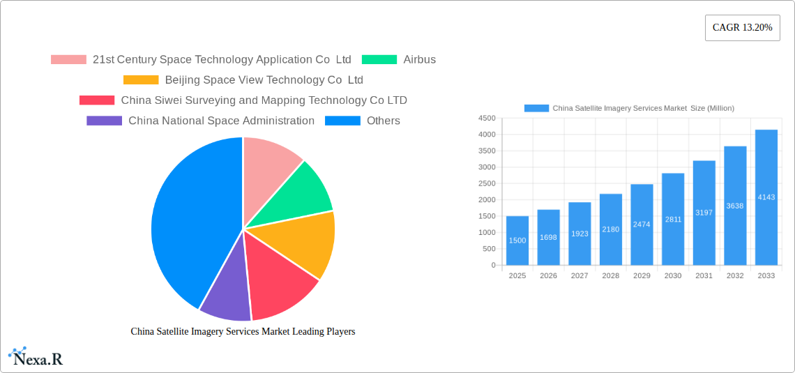
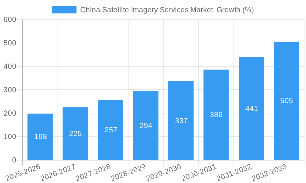
The China satellite imagery services market is experiencing robust growth, fueled by increasing government investment in infrastructure development, heightened demand for precision agriculture, and the expanding adoption of satellite imagery in various sectors. The market's Compound Annual Growth Rate (CAGR) of 13.20% from 2019 to 2024 indicates a significant upward trajectory, projected to continue through 2033. Key drivers include the nation's ambitious urbanization plans, necessitating precise mapping and monitoring; the agricultural sector's push for yield optimization through remote sensing technologies; and the growing importance of environmental monitoring and disaster management. Furthermore, advancements in satellite technology, offering higher resolution and faster data processing, are significantly boosting market adoption. The government sector, as a major end-user, is spearheading much of this growth through large-scale procurement and initiatives promoting the use of geospatial data. Segments like geospatial data acquisition and mapping, and natural resource management are expected to witness particularly strong growth. While data limitations currently exist for precise market sizing, projecting from the provided CAGR and considering market dynamics, we can reasonably anticipate substantial expansion across all segments and end-user categories. Competition is intense, involving both domestic players like 21st Century Space Technology Application Co Ltd and Beijing Space View Technology Co Ltd, and international giants like Airbus and Mapbox.
The competitive landscape is shaping up with both domestic and international companies vying for market share. The presence of government-backed organizations such as China National Space Administration alongside private entities indicates a diverse range of service offerings and technological capabilities. The market is witnessing a trend towards the integration of AI and machine learning to enhance data analysis and interpretation, further propelling growth. Challenges remain, including data privacy concerns and the need for consistent regulatory frameworks to ensure the responsible use of satellite imagery. However, the overall outlook for the China satellite imagery services market remains exceptionally positive, with substantial growth potential across multiple application domains over the next decade. Continued technological advancements and government support will be crucial drivers of future expansion.
China Satellite Imagery Services Market: A Comprehensive Report (2019-2033)
This in-depth report provides a comprehensive analysis of the China Satellite Imagery Services Market, encompassing market dynamics, growth trends, regional dominance, product landscape, key players, and future outlook. The study period covers 2019-2033, with 2025 as the base year and a forecast period of 2025-2033. The market is segmented by application (Geospatial Data Acquisition and Mapping, Natural Resource Management, Surveillance and Security, Conservation and Research, Disaster Management, Intelligence) and end-user (Government, Construction, Transportation and Logistics, Military and Defense, Forestry and Agriculture, Other End-Users). The report projects significant growth, driven by technological advancements and increasing demand across various sectors. The market size is expected to reach xx Million by 2033.
China Satellite Imagery Services Market Dynamics & Structure
The China satellite imagery services market exhibits a moderately concentrated structure, with both large multinational corporations and domestic players vying for market share. Technological innovation, particularly in high-resolution imagery, AI-powered analytics, and data processing, is a key driver. Government regulations, including data privacy and security concerns, significantly influence market operations. The market faces competition from alternative geospatial data sources, such as aerial photography and LiDAR. End-user demographics are diverse, encompassing government agencies, private businesses, and research institutions. The market has witnessed a moderate level of M&A activity in recent years, with strategic acquisitions aimed at expanding capabilities and market reach.
- Market Concentration: Moderately concentrated, with key players holding significant shares (xx%).
- Technological Innovation: High-resolution imagery, AI-driven analytics, and cloud-based solutions are key drivers.
- Regulatory Framework: Stringent data privacy and security regulations are influential.
- Competitive Substitutes: Aerial photography and LiDAR technologies pose some competition.
- End-User Demographics: Diverse, including government, commercial, and research sectors.
- M&A Trends: Moderate activity, focused on expanding capabilities and market presence. xx M&A deals were recorded between 2019 and 2024.
China Satellite Imagery Services Market Growth Trends & Insights
The China satellite imagery services market has experienced robust growth over the historical period (2019-2024), driven by increasing demand from various sectors. The market size expanded from xx Million in 2019 to xx Million in 2024, registering a CAGR of xx%. This growth is fueled by the widespread adoption of satellite imagery for applications such as urban planning, precision agriculture, and environmental monitoring. Technological disruptions, such as the development of high-resolution sensors and advanced analytics platforms, are further accelerating market expansion. Consumer behavior shifts towards data-driven decision-making are also contributing factors. The market is projected to continue its expansion during the forecast period (2025-2033), with a projected CAGR of xx%. Market penetration is expected to increase significantly across various sectors, particularly in the government and military segments.
Dominant Regions, Countries, or Segments in China Satellite Imagery Services Market
The Government sector dominates the end-user segment, driven by robust investment in national security and infrastructure projects. The Geospatial Data Acquisition and Mapping application segment displays the highest growth, supported by rapid urbanization and infrastructure development. Eastern China leads in market dominance due to its advanced technological infrastructure and high concentration of key players.
- Leading End-User Segment: Government (xx% market share). Key drivers include national security, infrastructure development, and environmental monitoring initiatives.
- Fastest-Growing Application Segment: Geospatial Data Acquisition and Mapping, fueled by urbanization and infrastructure projects.
- Dominant Region: Eastern China, benefiting from advanced technological infrastructure and industry concentration.
- Growth Potential: Significant potential exists in the Military and Defense, and Forestry and Agriculture sectors. Expansion of 5G and improved data access infrastructure in Western China will contribute to growth in this region.
China Satellite Imagery Services Market Product Landscape
The market offers a range of products and services, including high-resolution satellite imagery, value-added services (e.g., data processing, analytics, and GIS solutions), and cloud-based platforms. These offerings cater to specific end-user requirements. Recent product innovations focus on improved image resolution, enhanced spectral capabilities, and AI-powered analytics. Unique selling propositions include tailored data solutions, quick turnaround times, and cost-effective pricing strategies. Technological advancements in sensor technology, data processing algorithms, and cloud computing are shaping the product landscape, driving the market toward more efficient and reliable solutions.
Key Drivers, Barriers & Challenges in China Satellite Imagery Services Market
Key Drivers:
- Growing government investment in infrastructure development and national security.
- Rising adoption of satellite imagery across various sectors (e.g., agriculture, environmental monitoring).
- Technological advancements in satellite technology and data analytics.
Key Challenges:
- Stringent data privacy and security regulations.
- High initial investment costs associated with satellite acquisition and infrastructure development.
- Potential competition from other geospatial data sources. This limits the overall market size by approximately xx Million.
Emerging Opportunities in China Satellite Imagery Services Market
Untapped opportunities exist in the agricultural sector for precision farming applications, using satellite imagery for crop monitoring and yield prediction. Furthermore, the market can benefit from developing innovative applications for environmental monitoring, disaster management, and urban planning using AI and Machine Learning. Growth in the use of satellite imagery for logistics and transportation optimization also presents a significant emerging opportunity.
Growth Accelerators in the China Satellite Imagery Services Market Industry
Technological advancements in high-resolution sensors, AI-powered data analytics, and cloud computing are key growth catalysts. Strategic partnerships between satellite operators, data processing companies, and end-user organizations are crucial for market expansion. Government support through favorable policies and investments is also a significant factor. Increased investment in research and development and efforts towards developing indigenous satellite technology are fueling the long-term growth of this market.
Key Players Shaping the China Satellite Imagery Services Market Market
- 21st Century Space Technology Application Co Ltd
- Airbus
- Beijing Space View Technology Co Ltd
- China Siwei Surveying and Mapping Technology Co LTD
- China National Space Administration
- Mapbox
- Beijing Zero Map Information Technology Co Ltd
- CHANG GUANG SATELLITE TECHNOLOGY CO LTD
- National Satellite Meteorological Center
- HEAD Aerospace Group
Notable Milestones in China Satellite Imagery Services Market Sector
- June 2023: China shared 400 scenes (1.5 TB) of satellite imagery data with BRICS countries, creating new business opportunities for domestic vendors.
- January 2023: Spacety supplied synthetic aperture radar satellite images to a Russian technology firm, highlighting the military applications of Chinese satellite imagery services.
In-Depth China Satellite Imagery Services Market Market Outlook
The China satellite imagery services market is poised for significant growth, driven by technological advancements, increasing government support, and expanding applications across various sectors. The market's future potential is considerable, with substantial opportunities for both established players and new entrants. Strategic partnerships, investments in R&D, and innovative data solutions will play a key role in shaping the market's future trajectory. The market is predicted to maintain strong growth momentum throughout the forecast period, making it an attractive sector for investment and expansion.
China Satellite Imagery Services Market Segmentation
-
1. Application
- 1.1. Geospatial Data Acquisition and Mapping
- 1.2. Natural Resource Management
- 1.3. Surveillance and Security
- 1.4. Conservation and Research
- 1.5. Disaster Management
- 1.6. Intelligence
-
2. End-User
- 2.1. Government
- 2.2. Construction
- 2.3. Transportation and Logistics
- 2.4. Military and Defense
- 2.5. Forestry and Agriculture
- 2.6. Other End-Users
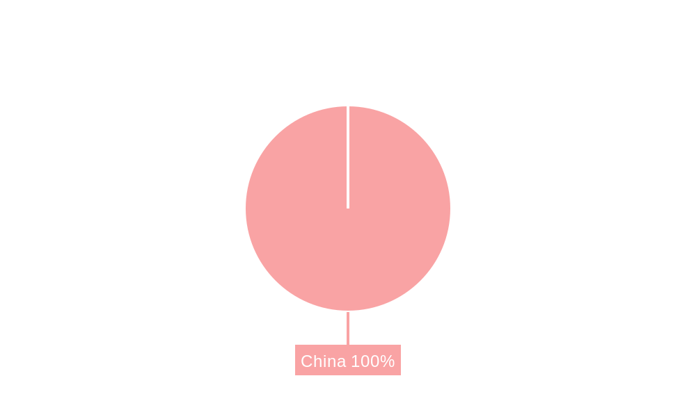
China Satellite Imagery Services Market Segmentation By Geography
- 1. China
China Satellite Imagery Services Market REPORT HIGHLIGHTS
| Aspects | Details |
|---|---|
| Study Period | 2019-2033 |
| Base Year | 2024 |
| Estimated Year | 2025 |
| Forecast Period | 2025-2033 |
| Historical Period | 2019-2024 |
| Growth Rate | CAGR of 13.20% from 2019-2033 |
| Segmentation |
|
Table of Contents
- 1. Introduction
- 1.1. Research Scope
- 1.2. Market Segmentation
- 1.3. Research Methodology
- 1.4. Definitions and Assumptions
- 2. Executive Summary
- 2.1. Introduction
- 3. Market Dynamics
- 3.1. Introduction
- 3.2. Market Drivers
- 3.2.1. The country's Investments in Space Technology and Defence; Adoption of Big Data and Imagery Analytics
- 3.3. Market Restrains
- 3.3.1. High Cost of Satellite Imaging Data Acquisition and Processing; High-resolution Images Offered by Other Imaging Technologies
- 3.4. Market Trends
- 3.4.1. The country's Investments in Space Technology and Defense Drives Market Growth.
- 4. Market Factor Analysis
- 4.1. Porters Five Forces
- 4.2. Supply/Value Chain
- 4.3. PESTEL analysis
- 4.4. Market Entropy
- 4.5. Patent/Trademark Analysis
- 5. China Satellite Imagery Services Market Analysis, Insights and Forecast, 2019-2031
- 5.1. Market Analysis, Insights and Forecast - by Application
- 5.1.1. Geospatial Data Acquisition and Mapping
- 5.1.2. Natural Resource Management
- 5.1.3. Surveillance and Security
- 5.1.4. Conservation and Research
- 5.1.5. Disaster Management
- 5.1.6. Intelligence
- 5.2. Market Analysis, Insights and Forecast - by End-User
- 5.2.1. Government
- 5.2.2. Construction
- 5.2.3. Transportation and Logistics
- 5.2.4. Military and Defense
- 5.2.5. Forestry and Agriculture
- 5.2.6. Other End-Users
- 5.3. Market Analysis, Insights and Forecast - by Region
- 5.3.1. China
- 5.1. Market Analysis, Insights and Forecast - by Application
- 6. Competitive Analysis
- 6.1. Market Share Analysis 2024
- 6.2. Company Profiles
- 6.2.1 21st Century Space Technology Application Co Ltd
- 6.2.1.1. Overview
- 6.2.1.2. Products
- 6.2.1.3. SWOT Analysis
- 6.2.1.4. Recent Developments
- 6.2.1.5. Financials (Based on Availability)
- 6.2.2 Airbus
- 6.2.2.1. Overview
- 6.2.2.2. Products
- 6.2.2.3. SWOT Analysis
- 6.2.2.4. Recent Developments
- 6.2.2.5. Financials (Based on Availability)
- 6.2.3 Beijing Space View Technology Co Ltd
- 6.2.3.1. Overview
- 6.2.3.2. Products
- 6.2.3.3. SWOT Analysis
- 6.2.3.4. Recent Developments
- 6.2.3.5. Financials (Based on Availability)
- 6.2.4 China Siwei Surveying and Mapping Technology Co LTD
- 6.2.4.1. Overview
- 6.2.4.2. Products
- 6.2.4.3. SWOT Analysis
- 6.2.4.4. Recent Developments
- 6.2.4.5. Financials (Based on Availability)
- 6.2.5 China National Space Administration
- 6.2.5.1. Overview
- 6.2.5.2. Products
- 6.2.5.3. SWOT Analysis
- 6.2.5.4. Recent Developments
- 6.2.5.5. Financials (Based on Availability)
- 6.2.6 Mapbox
- 6.2.6.1. Overview
- 6.2.6.2. Products
- 6.2.6.3. SWOT Analysis
- 6.2.6.4. Recent Developments
- 6.2.6.5. Financials (Based on Availability)
- 6.2.7 Beijing Zero Map Information Technology Co Ltd
- 6.2.7.1. Overview
- 6.2.7.2. Products
- 6.2.7.3. SWOT Analysis
- 6.2.7.4. Recent Developments
- 6.2.7.5. Financials (Based on Availability)
- 6.2.8 CHANG GUANG SATELLITE TECHNOLOGY CO LTD
- 6.2.8.1. Overview
- 6.2.8.2. Products
- 6.2.8.3. SWOT Analysis
- 6.2.8.4. Recent Developments
- 6.2.8.5. Financials (Based on Availability)
- 6.2.9 National Satellite Meteorological Center
- 6.2.9.1. Overview
- 6.2.9.2. Products
- 6.2.9.3. SWOT Analysis
- 6.2.9.4. Recent Developments
- 6.2.9.5. Financials (Based on Availability)
- 6.2.10 HEAD Aerospace Group
- 6.2.10.1. Overview
- 6.2.10.2. Products
- 6.2.10.3. SWOT Analysis
- 6.2.10.4. Recent Developments
- 6.2.10.5. Financials (Based on Availability)
- 6.2.1 21st Century Space Technology Application Co Ltd
List of Figures
- Figure 1: China Satellite Imagery Services Market Revenue Breakdown (Million, %) by Product 2024 & 2032
- Figure 2: China Satellite Imagery Services Market Share (%) by Company 2024
List of Tables
- Table 1: China Satellite Imagery Services Market Revenue Million Forecast, by Region 2019 & 2032
- Table 2: China Satellite Imagery Services Market Revenue Million Forecast, by Application 2019 & 2032
- Table 3: China Satellite Imagery Services Market Revenue Million Forecast, by End-User 2019 & 2032
- Table 4: China Satellite Imagery Services Market Revenue Million Forecast, by Region 2019 & 2032
- Table 5: China Satellite Imagery Services Market Revenue Million Forecast, by Country 2019 & 2032
- Table 6: China Satellite Imagery Services Market Revenue Million Forecast, by Application 2019 & 2032
- Table 7: China Satellite Imagery Services Market Revenue Million Forecast, by End-User 2019 & 2032
- Table 8: China Satellite Imagery Services Market Revenue Million Forecast, by Country 2019 & 2032
Frequently Asked Questions
1. What is the projected Compound Annual Growth Rate (CAGR) of the China Satellite Imagery Services Market ?
The projected CAGR is approximately 13.20%.
2. Which companies are prominent players in the China Satellite Imagery Services Market ?
Key companies in the market include 21st Century Space Technology Application Co Ltd, Airbus, Beijing Space View Technology Co Ltd, China Siwei Surveying and Mapping Technology Co LTD, China National Space Administration, Mapbox, Beijing Zero Map Information Technology Co Ltd, CHANG GUANG SATELLITE TECHNOLOGY CO LTD, National Satellite Meteorological Center, HEAD Aerospace Group.
3. What are the main segments of the China Satellite Imagery Services Market ?
The market segments include Application, End-User.
4. Can you provide details about the market size?
The market size is estimated to be USD XX Million as of 2022.
5. What are some drivers contributing to market growth?
The country's Investments in Space Technology and Defence; Adoption of Big Data and Imagery Analytics.
6. What are the notable trends driving market growth?
The country's Investments in Space Technology and Defense Drives Market Growth..
7. Are there any restraints impacting market growth?
High Cost of Satellite Imaging Data Acquisition and Processing; High-resolution Images Offered by Other Imaging Technologies.
8. Can you provide examples of recent developments in the market?
June 2023: The country awarded a contract to share satellite Imagery data with BRICS countries after the signing of an agreement on Cooperation on the BRICS Remote Sensing Satellite Constellation and shared 400 scenes of satellite imagery data with the BRICS countries, with the total volume amounting to 1.5 TB, which supports the growth of satellite imagery services market in China by creating a business opportunity for the Chinese vendors.
9. What pricing options are available for accessing the report?
Pricing options include single-user, multi-user, and enterprise licenses priced at USD 3800, USD 4500, and USD 5800 respectively.
10. Is the market size provided in terms of value or volume?
The market size is provided in terms of value, measured in Million.
11. Are there any specific market keywords associated with the report?
Yes, the market keyword associated with the report is "China Satellite Imagery Services Market ," which aids in identifying and referencing the specific market segment covered.
12. How do I determine which pricing option suits my needs best?
The pricing options vary based on user requirements and access needs. Individual users may opt for single-user licenses, while businesses requiring broader access may choose multi-user or enterprise licenses for cost-effective access to the report.
13. Are there any additional resources or data provided in the China Satellite Imagery Services Market report?
While the report offers comprehensive insights, it's advisable to review the specific contents or supplementary materials provided to ascertain if additional resources or data are available.
14. How can I stay updated on further developments or reports in the China Satellite Imagery Services Market ?
To stay informed about further developments, trends, and reports in the China Satellite Imagery Services Market , consider subscribing to industry newsletters, following relevant companies and organizations, or regularly checking reputable industry news sources and publications.
Methodology
Step 1 - Identification of Relevant Samples Size from Population Database


Step 2 - Approaches for Defining Global Market Size (Value, Volume* & Price*)

Note*: In applicable scenarios
Step 3 - Data Sources
Primary Research
- Web Analytics
- Survey Reports
- Research Institute
- Latest Research Reports
- Opinion Leaders
Secondary Research
- Annual Reports
- White Paper
- Latest Press Release
- Industry Association
- Paid Database
- Investor Presentations

Step 4 - Data Triangulation
Involves using different sources of information in order to increase the validity of a study
These sources are likely to be stakeholders in a program - participants, other researchers, program staff, other community members, and so on.
Then we put all data in single framework & apply various statistical tools to find out the dynamic on the market.
During the analysis stage, feedback from the stakeholder groups would be compared to determine areas of agreement as well as areas of divergence
