

Key Insights
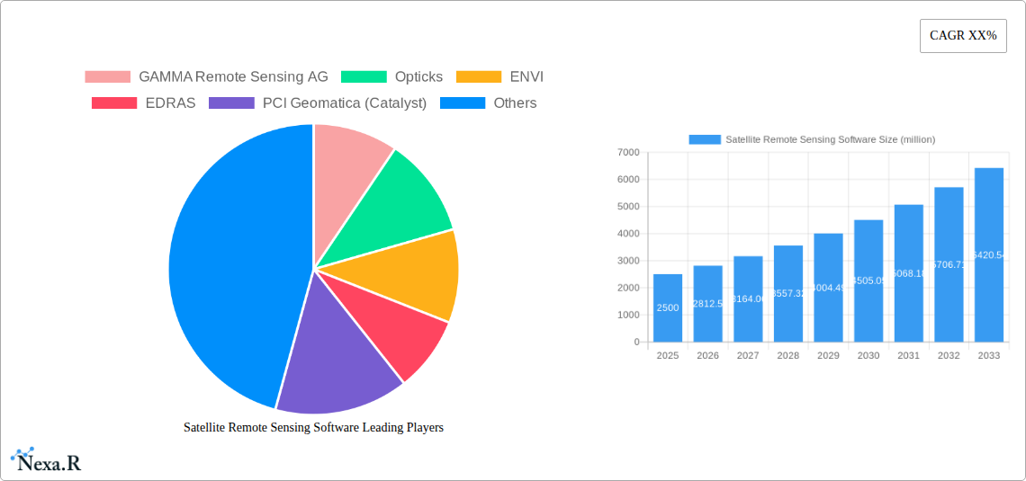
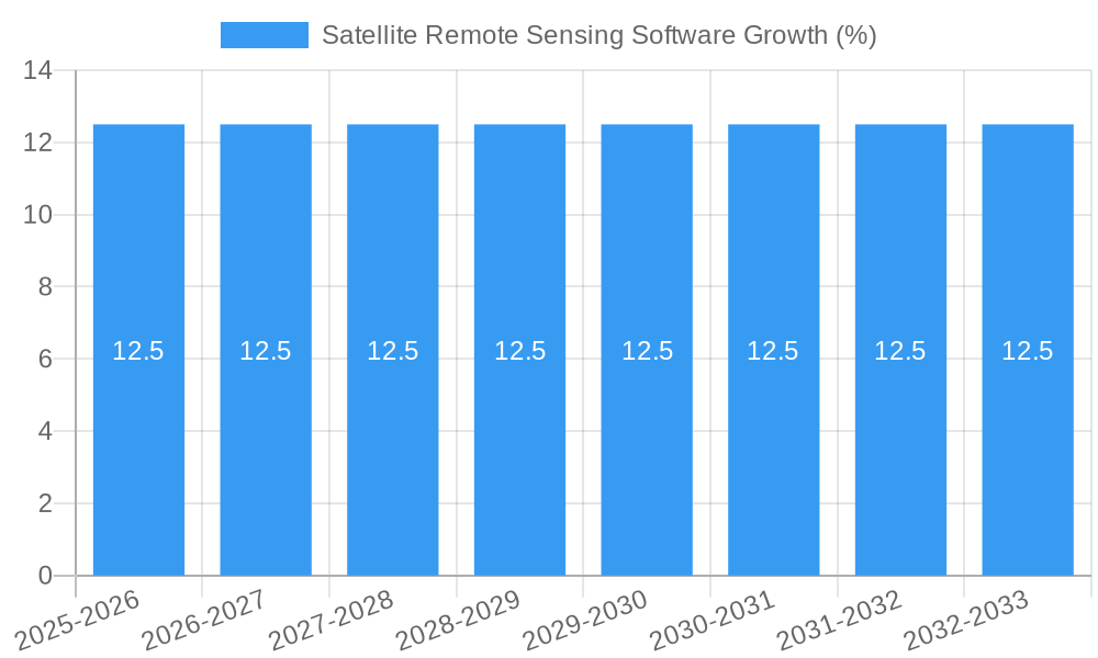
The global Satellite Remote Sensing Software market is poised for significant expansion, projected to reach an estimated USD 2.5 billion by 2025, with a robust Compound Annual Growth Rate (CAGR) of 12.5% anticipated from 2025 to 2033. This growth is fueled by a confluence of factors, most notably the escalating demand for precise environmental monitoring and resource management across various sectors. The increasing adoption of satellite imagery for agricultural precision, water resource optimization, and detailed forest management is a primary driver. Furthermore, the public sector's reliance on satellite data for urban planning, disaster response, and national security applications significantly bolsters market penetration. The continuous advancements in satellite technology, leading to higher resolution imagery and more sophisticated data processing capabilities, are creating new opportunities and enhancing the utility of remote sensing software. This technological evolution, coupled with a growing awareness of the benefits of data-driven decision-making, is creating a fertile ground for market expansion.
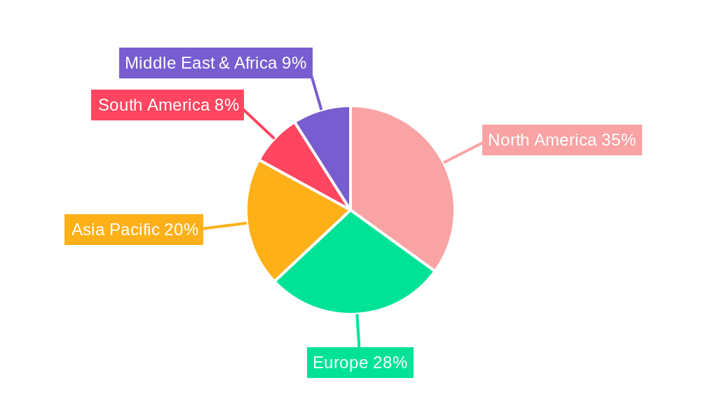
The market is characterized by a dynamic competitive landscape and evolving technological trends. While proprietary software solutions currently hold a substantial market share, open-source alternatives like QGIS and GRASS GIS are gaining traction due to their cost-effectiveness and flexibility, particularly among academic institutions and smaller organizations. Key restraining factors include the high initial investment for sophisticated software and hardware, coupled with the need for skilled professionals to effectively interpret and utilize the complex data generated. However, these challenges are being mitigated by the increasing availability of cloud-based solutions and user-friendly interfaces. Geographically, North America and Europe currently lead the market, driven by advanced technological infrastructure and significant government investment in space programs and environmental initiatives. The Asia Pacific region, however, is emerging as a high-growth segment, propelled by rapid urbanization, industrialization, and a burgeoning interest in sustainable development, indicating a shift in market dynamics and a strong future outlook.
Satellite Remote Sensing Software Market Dynamics & Structure
The satellite remote sensing software market exhibits a moderate concentration, with key players like ESRI, ENVI, and Trimble eCognition holding significant influence, complemented by a growing ecosystem of specialized and open-source solutions. Technological innovation is primarily driven by advancements in artificial intelligence (AI) and machine learning (ML) for automated data analysis, improved sensor resolution, and the integration of cloud computing platforms for enhanced scalability and accessibility. Regulatory frameworks, while generally supportive of data sharing and scientific research, can pose challenges in terms of data security and privacy concerns, particularly for sensitive applications. Competitive product substitutes include traditional aerial imagery analysis and ground-based data collection methods, though satellite remote sensing offers unparalleled spatial coverage and temporal frequency. End-user demographics are increasingly diverse, spanning from academic researchers and government agencies to commercial entities in agriculture, forestry, and disaster management. Mergers and acquisitions (M&A) trends are notable, with larger established firms acquiring innovative startups to expand their technological capabilities and market reach. For instance, a predicted 15% of market participants are likely to engage in M&A activities within the next five years.
- Market Concentration: Moderate, with significant presence of established vendors and a thriving open-source community.
- Technological Innovation Drivers: AI/ML for data interpretation, cloud integration, and enhanced sensor capabilities.
- Regulatory Frameworks: Focus on data security, privacy, and fostering collaborative research.
- Competitive Product Substitutes: Aerial imagery, ground surveys, and other geospatial analysis tools.
- End-User Demographics: Broad spectrum from public sector to commercial industries.
- M&A Trends: Strategic acquisitions to gain technological edge and market share.
Satellite Remote Sensing Software Growth Trends & Insights
The global satellite remote sensing software market is poised for robust growth, projected to expand from approximately $1,800 million in 2024 to over $3,500 million by 2033, exhibiting a compound annual growth rate (CAGR) of approximately 7.5%. This significant expansion is fueled by the increasing adoption of satellite imagery for a wide array of applications, ranging from precision agriculture and environmental monitoring to urban planning and national security. The market's evolution is characterized by a shift towards cloud-based solutions, offering greater accessibility, scalability, and collaborative capabilities for users. Technological disruptions, particularly in the realm of AI and machine learning, are revolutionizing data analysis, enabling faster and more accurate interpretation of complex datasets. This leads to enhanced insights for decision-making across various sectors. Consumer behavior is also adapting, with an increasing demand for user-friendly interfaces and integrated workflows that streamline the entire remote sensing process, from data acquisition to final analysis and reporting. The penetration of satellite remote sensing software is expected to rise significantly, moving from an estimated 45% in 2024 to over 70% by 2033, indicating its growing indispensability. Furthermore, the increasing availability of high-resolution satellite data from constellations like Sentinel, Landsat, and commercial providers further accelerates adoption rates by offering richer and more detailed information. The integration of real-time data streams and predictive analytics is another key trend, empowering users to respond proactively to dynamic environmental and economic changes.
Dominant Regions, Countries, or Segments in Satellite Remote Sensing Software
North America currently leads the satellite remote sensing software market, driven by significant investments in defense and intelligence, a mature technology infrastructure, and a strong research and development ecosystem. The United States, in particular, accounts for an estimated 35% of the global market share in this region, propelled by its extensive use in public sector applications like disaster management, environmental protection, and agricultural monitoring. The presence of major industry players such as ESRI and ENVI, coupled with robust academic institutions, fosters continuous innovation and adoption.
In terms of Applications, Agriculture is emerging as a dominant segment, projected to contribute over 25% to the market's overall growth by 2033. The increasing need for precision farming, crop yield prediction, and sustainable land management practices is a primary driver. Satellite remote sensing software enables farmers to monitor crop health, optimize irrigation, detect diseases, and manage pests more effectively, leading to improved yields and reduced resource wastage. The global value of the agriculture segment is expected to reach $900 million by 2033.
Within the Types of software, Non-open Source Software currently holds a larger market share, estimated at around 60%, due to the advanced features, dedicated support, and integrated solutions offered by commercial vendors. However, the Open Source Software segment is experiencing a rapid growth trajectory, with an anticipated CAGR of 9% over the forecast period. This is driven by its cost-effectiveness, flexibility, and the strong community support that fosters rapid development and customization. Key open-source platforms like QGIS and GRASS GIS are gaining traction, particularly among academic institutions and budget-conscious organizations. The market for open-source solutions is projected to expand from $720 million in 2024 to over $1,600 million by 2033.
- Dominant Region: North America (especially the United States) due to defense, R&D, and public sector adoption.
- Dominant Application Segment: Agriculture, driven by precision farming and sustainable land management.
- Dominant Software Type: Non-open Source Software, with rapid growth in Open Source Software due to cost-effectiveness and flexibility.
Satellite Remote Sensing Software Product Landscape
The satellite remote sensing software product landscape is characterized by continuous innovation in data processing and analysis capabilities. Key advancements include the integration of sophisticated AI and ML algorithms for automated feature extraction, object detection, and change analysis, significantly reducing manual interpretation efforts. Enhanced visualization tools and 3D rendering capabilities are improving the understanding of complex geographical data. Many platforms now offer seamless integration with cloud-based data repositories and processing services, enabling scalable and efficient handling of vast datasets. Furthermore, specialized modules for specific applications like urban sprawl monitoring, disaster impact assessment, and environmental compliance are gaining prominence, offering tailored solutions for diverse industry needs. The unique selling proposition of leading software lies in their comprehensive feature sets, user-friendly interfaces, and robust support.
Key Drivers, Barriers & Challenges in Satellite Remote Sensing Software
Key Drivers:
- Technological Advancements: Proliferation of AI/ML for data analysis, improved sensor technology offering higher resolution and spectral diversity.
- Increasing Demand for Geospatial Data: Growing needs in precision agriculture, urban planning, environmental monitoring, and disaster management.
- Cost Reduction in Satellite Data: Increased availability of free and commercial satellite imagery at competitive prices.
- Cloud Computing Adoption: Facilitating scalable data processing, storage, and accessibility.
Barriers & Challenges:
- High Initial Investment: Cost of specialized software licenses and skilled personnel.
- Data Processing Complexity: Handling and interpreting large volumes of complex satellite data can be challenging for novice users.
- Data Quality and Consistency: Variations in sensor calibration, atmospheric interference, and cloud cover can impact data reliability.
- Interoperability Issues: Challenges in integrating data from different satellite sensors and software platforms.
- Regulatory Hurdles: Data privacy and security concerns, particularly for sensitive governmental or commercial applications.
- Skilled Workforce Shortage: Demand for trained remote sensing professionals often outstrips supply.
Emerging Opportunities in Satellite Remote Sensing Software
Emerging opportunities lie in the development of real-time, AI-driven analytics platforms that can provide immediate insights for time-sensitive applications like natural disaster response and agricultural anomaly detection. The growth of the Internet of Things (IoT) ecosystem, with its vast array of sensors, presents opportunities for integrating satellite data with ground-level measurements for more comprehensive environmental monitoring. Furthermore, the expansion of satellite constellations offering higher temporal and spatial resolutions will unlock new applications in areas such as infrastructure monitoring, precision resource management, and personalized environmental services. The increasing focus on climate change mitigation and adaptation is also a significant driver for novel applications in carbon monitoring, deforestation tracking, and climate modeling.
Growth Accelerators in the Satellite Remote Sensing Software Industry
Long-term growth in the satellite remote sensing software industry is primarily being accelerated by breakthroughs in artificial intelligence and machine learning, enabling automated and sophisticated data interpretation at scale. The increasing accessibility and affordability of satellite imagery, coupled with the growth of cloud computing infrastructure, are lowering barriers to entry and expanding the user base. Strategic partnerships between software developers, data providers, and end-user industries are fostering tailored solutions and driving market penetration. Furthermore, government initiatives promoting the use of geospatial data for public good, such as environmental protection and urban development, are acting as significant catalysts for widespread adoption and innovation.
Key Players Shaping the Satellite Remote Sensing Software Market
- GAMMA Remote Sensing AG
- Opticks
- ENVI
- EDRAS
- PCI Geomatica (Catalyst)
- eCOGNITION
- ESRI
- QGIS
- ArcGIS Pro
- Trimble eCognition
- Whitebox GAT
- SAGA GIS
- PolSARPro
- GRASS GIS
- ILWIS
Notable Milestones in Satellite Remote Sensing Software Sector
- 2019: Launch of enhanced AI/ML algorithms within ENVI software for automated feature extraction.
- 2020: ESRI's ArcGIS Pro 2.7 release introduced advanced raster analysis tools and cloud integration capabilities.
- 2021: Trimble acquired eCognition, strengthening its portfolio in advanced geospatial data analysis.
- 2021: QGIS 3.20 release focused on improved performance and user experience for open-source users.
- 2022: PCI Geomatica launched Catalyst, a cloud-based platform for automated geospatial workflows.
- 2023: Opticks announced significant advancements in real-time satellite data processing for disaster management.
- 2024: Development of specialized modules for climate change monitoring within various commercial software.
- 2024: Increased collaboration between open-source projects like GRASS GIS and SAGA GIS for enhanced interoperability.
- 2025: Projected widespread adoption of federated learning for analyzing sensitive satellite data.
- 2025: Emergence of new AI-powered platforms for predictive analytics in agriculture.
- 2026: Expected advancements in quantum computing for satellite data processing.
- 2028: Integration of satellite data with digital twin technologies for urban planning.
- 2030: Maturation of real-time Earth observation networks for continuous monitoring.
- 2033: Projected widespread use of autonomous systems for satellite data analysis and application.
In-Depth Satellite Remote Sensing Software Market Outlook
The satellite remote sensing software market is set for continued substantial growth, fueled by the ongoing integration of advanced AI and machine learning techniques that promise to democratize sophisticated data analysis. The expansion of cloud infrastructure will further enhance accessibility and scalability, making powerful tools available to a broader user base. Strategic alliances and the development of specialized, application-centric solutions will drive adoption across diverse sectors. The market's future trajectory points towards increasingly intelligent, automated, and integrated platforms, empowering users with actionable insights for informed decision-making in an ever-changing global landscape.
Satellite Remote Sensing Software Segmentation
-
1. Application
- 1.1. Agriculture
- 1.2. Water Conservancy
- 1.3. Forest Management
- 1.4. Public Sector
- 1.5. Others
-
2. Types
- 2.1. Open Source Software
- 2.2. Non-open Source Software
Satellite Remote Sensing Software Segmentation By Geography
-
1. North America
- 1.1. United States
- 1.2. Canada
- 1.3. Mexico
-
2. South America
- 2.1. Brazil
- 2.2. Argentina
- 2.3. Rest of South America
-
3. Europe
- 3.1. United Kingdom
- 3.2. Germany
- 3.3. France
- 3.4. Italy
- 3.5. Spain
- 3.6. Russia
- 3.7. Benelux
- 3.8. Nordics
- 3.9. Rest of Europe
-
4. Middle East & Africa
- 4.1. Turkey
- 4.2. Israel
- 4.3. GCC
- 4.4. North Africa
- 4.5. South Africa
- 4.6. Rest of Middle East & Africa
-
5. Asia Pacific
- 5.1. China
- 5.2. India
- 5.3. Japan
- 5.4. South Korea
- 5.5. ASEAN
- 5.6. Oceania
- 5.7. Rest of Asia Pacific
Satellite Remote Sensing Software REPORT HIGHLIGHTS
| Aspects | Details |
|---|---|
| Study Period | 2019-2033 |
| Base Year | 2024 |
| Estimated Year | 2025 |
| Forecast Period | 2025-2033 |
| Historical Period | 2019-2024 |
| Growth Rate | CAGR of XX% from 2019-2033 |
| Segmentation |
|
Table of Contents
- 1. Introduction
- 1.1. Research Scope
- 1.2. Market Segmentation
- 1.3. Research Methodology
- 1.4. Definitions and Assumptions
- 2. Executive Summary
- 2.1. Introduction
- 3. Market Dynamics
- 3.1. Introduction
- 3.2. Market Drivers
- 3.3. Market Restrains
- 3.4. Market Trends
- 4. Market Factor Analysis
- 4.1. Porters Five Forces
- 4.2. Supply/Value Chain
- 4.3. PESTEL analysis
- 4.4. Market Entropy
- 4.5. Patent/Trademark Analysis
- 5. Global Satellite Remote Sensing Software Analysis, Insights and Forecast, 2019-2031
- 5.1. Market Analysis, Insights and Forecast - by Application
- 5.1.1. Agriculture
- 5.1.2. Water Conservancy
- 5.1.3. Forest Management
- 5.1.4. Public Sector
- 5.1.5. Others
- 5.2. Market Analysis, Insights and Forecast - by Types
- 5.2.1. Open Source Software
- 5.2.2. Non-open Source Software
- 5.3. Market Analysis, Insights and Forecast - by Region
- 5.3.1. North America
- 5.3.2. South America
- 5.3.3. Europe
- 5.3.4. Middle East & Africa
- 5.3.5. Asia Pacific
- 5.1. Market Analysis, Insights and Forecast - by Application
- 6. North America Satellite Remote Sensing Software Analysis, Insights and Forecast, 2019-2031
- 6.1. Market Analysis, Insights and Forecast - by Application
- 6.1.1. Agriculture
- 6.1.2. Water Conservancy
- 6.1.3. Forest Management
- 6.1.4. Public Sector
- 6.1.5. Others
- 6.2. Market Analysis, Insights and Forecast - by Types
- 6.2.1. Open Source Software
- 6.2.2. Non-open Source Software
- 6.1. Market Analysis, Insights and Forecast - by Application
- 7. South America Satellite Remote Sensing Software Analysis, Insights and Forecast, 2019-2031
- 7.1. Market Analysis, Insights and Forecast - by Application
- 7.1.1. Agriculture
- 7.1.2. Water Conservancy
- 7.1.3. Forest Management
- 7.1.4. Public Sector
- 7.1.5. Others
- 7.2. Market Analysis, Insights and Forecast - by Types
- 7.2.1. Open Source Software
- 7.2.2. Non-open Source Software
- 7.1. Market Analysis, Insights and Forecast - by Application
- 8. Europe Satellite Remote Sensing Software Analysis, Insights and Forecast, 2019-2031
- 8.1. Market Analysis, Insights and Forecast - by Application
- 8.1.1. Agriculture
- 8.1.2. Water Conservancy
- 8.1.3. Forest Management
- 8.1.4. Public Sector
- 8.1.5. Others
- 8.2. Market Analysis, Insights and Forecast - by Types
- 8.2.1. Open Source Software
- 8.2.2. Non-open Source Software
- 8.1. Market Analysis, Insights and Forecast - by Application
- 9. Middle East & Africa Satellite Remote Sensing Software Analysis, Insights and Forecast, 2019-2031
- 9.1. Market Analysis, Insights and Forecast - by Application
- 9.1.1. Agriculture
- 9.1.2. Water Conservancy
- 9.1.3. Forest Management
- 9.1.4. Public Sector
- 9.1.5. Others
- 9.2. Market Analysis, Insights and Forecast - by Types
- 9.2.1. Open Source Software
- 9.2.2. Non-open Source Software
- 9.1. Market Analysis, Insights and Forecast - by Application
- 10. Asia Pacific Satellite Remote Sensing Software Analysis, Insights and Forecast, 2019-2031
- 10.1. Market Analysis, Insights and Forecast - by Application
- 10.1.1. Agriculture
- 10.1.2. Water Conservancy
- 10.1.3. Forest Management
- 10.1.4. Public Sector
- 10.1.5. Others
- 10.2. Market Analysis, Insights and Forecast - by Types
- 10.2.1. Open Source Software
- 10.2.2. Non-open Source Software
- 10.1. Market Analysis, Insights and Forecast - by Application
- 11. Competitive Analysis
- 11.1. Global Market Share Analysis 2024
- 11.2. Company Profiles
- 11.2.1 GAMMA Remote Sensing AG
- 11.2.1.1. Overview
- 11.2.1.2. Products
- 11.2.1.3. SWOT Analysis
- 11.2.1.4. Recent Developments
- 11.2.1.5. Financials (Based on Availability)
- 11.2.2 Opticks
- 11.2.2.1. Overview
- 11.2.2.2. Products
- 11.2.2.3. SWOT Analysis
- 11.2.2.4. Recent Developments
- 11.2.2.5. Financials (Based on Availability)
- 11.2.3 ENVI
- 11.2.3.1. Overview
- 11.2.3.2. Products
- 11.2.3.3. SWOT Analysis
- 11.2.3.4. Recent Developments
- 11.2.3.5. Financials (Based on Availability)
- 11.2.4 EDRAS
- 11.2.4.1. Overview
- 11.2.4.2. Products
- 11.2.4.3. SWOT Analysis
- 11.2.4.4. Recent Developments
- 11.2.4.5. Financials (Based on Availability)
- 11.2.5 PCI Geomatica (Catalyst)
- 11.2.5.1. Overview
- 11.2.5.2. Products
- 11.2.5.3. SWOT Analysis
- 11.2.5.4. Recent Developments
- 11.2.5.5. Financials (Based on Availability)
- 11.2.6 eCOGNITION
- 11.2.6.1. Overview
- 11.2.6.2. Products
- 11.2.6.3. SWOT Analysis
- 11.2.6.4. Recent Developments
- 11.2.6.5. Financials (Based on Availability)
- 11.2.7 ESRI
- 11.2.7.1. Overview
- 11.2.7.2. Products
- 11.2.7.3. SWOT Analysis
- 11.2.7.4. Recent Developments
- 11.2.7.5. Financials (Based on Availability)
- 11.2.8 QGIS
- 11.2.8.1. Overview
- 11.2.8.2. Products
- 11.2.8.3. SWOT Analysis
- 11.2.8.4. Recent Developments
- 11.2.8.5. Financials (Based on Availability)
- 11.2.9 ArcGIS Pro
- 11.2.9.1. Overview
- 11.2.9.2. Products
- 11.2.9.3. SWOT Analysis
- 11.2.9.4. Recent Developments
- 11.2.9.5. Financials (Based on Availability)
- 11.2.10 Trimble eCognition
- 11.2.10.1. Overview
- 11.2.10.2. Products
- 11.2.10.3. SWOT Analysis
- 11.2.10.4. Recent Developments
- 11.2.10.5. Financials (Based on Availability)
- 11.2.11 Whitebox GAT
- 11.2.11.1. Overview
- 11.2.11.2. Products
- 11.2.11.3. SWOT Analysis
- 11.2.11.4. Recent Developments
- 11.2.11.5. Financials (Based on Availability)
- 11.2.12 SAGA GIS
- 11.2.12.1. Overview
- 11.2.12.2. Products
- 11.2.12.3. SWOT Analysis
- 11.2.12.4. Recent Developments
- 11.2.12.5. Financials (Based on Availability)
- 11.2.13 PolSARPro
- 11.2.13.1. Overview
- 11.2.13.2. Products
- 11.2.13.3. SWOT Analysis
- 11.2.13.4. Recent Developments
- 11.2.13.5. Financials (Based on Availability)
- 11.2.14 GRASS GIS
- 11.2.14.1. Overview
- 11.2.14.2. Products
- 11.2.14.3. SWOT Analysis
- 11.2.14.4. Recent Developments
- 11.2.14.5. Financials (Based on Availability)
- 11.2.15 ILWIS
- 11.2.15.1. Overview
- 11.2.15.2. Products
- 11.2.15.3. SWOT Analysis
- 11.2.15.4. Recent Developments
- 11.2.15.5. Financials (Based on Availability)
- 11.2.1 GAMMA Remote Sensing AG
List of Figures
- Figure 1: Global Satellite Remote Sensing Software Revenue Breakdown (million, %) by Region 2024 & 2032
- Figure 2: North America Satellite Remote Sensing Software Revenue (million), by Application 2024 & 2032
- Figure 3: North America Satellite Remote Sensing Software Revenue Share (%), by Application 2024 & 2032
- Figure 4: North America Satellite Remote Sensing Software Revenue (million), by Types 2024 & 2032
- Figure 5: North America Satellite Remote Sensing Software Revenue Share (%), by Types 2024 & 2032
- Figure 6: North America Satellite Remote Sensing Software Revenue (million), by Country 2024 & 2032
- Figure 7: North America Satellite Remote Sensing Software Revenue Share (%), by Country 2024 & 2032
- Figure 8: South America Satellite Remote Sensing Software Revenue (million), by Application 2024 & 2032
- Figure 9: South America Satellite Remote Sensing Software Revenue Share (%), by Application 2024 & 2032
- Figure 10: South America Satellite Remote Sensing Software Revenue (million), by Types 2024 & 2032
- Figure 11: South America Satellite Remote Sensing Software Revenue Share (%), by Types 2024 & 2032
- Figure 12: South America Satellite Remote Sensing Software Revenue (million), by Country 2024 & 2032
- Figure 13: South America Satellite Remote Sensing Software Revenue Share (%), by Country 2024 & 2032
- Figure 14: Europe Satellite Remote Sensing Software Revenue (million), by Application 2024 & 2032
- Figure 15: Europe Satellite Remote Sensing Software Revenue Share (%), by Application 2024 & 2032
- Figure 16: Europe Satellite Remote Sensing Software Revenue (million), by Types 2024 & 2032
- Figure 17: Europe Satellite Remote Sensing Software Revenue Share (%), by Types 2024 & 2032
- Figure 18: Europe Satellite Remote Sensing Software Revenue (million), by Country 2024 & 2032
- Figure 19: Europe Satellite Remote Sensing Software Revenue Share (%), by Country 2024 & 2032
- Figure 20: Middle East & Africa Satellite Remote Sensing Software Revenue (million), by Application 2024 & 2032
- Figure 21: Middle East & Africa Satellite Remote Sensing Software Revenue Share (%), by Application 2024 & 2032
- Figure 22: Middle East & Africa Satellite Remote Sensing Software Revenue (million), by Types 2024 & 2032
- Figure 23: Middle East & Africa Satellite Remote Sensing Software Revenue Share (%), by Types 2024 & 2032
- Figure 24: Middle East & Africa Satellite Remote Sensing Software Revenue (million), by Country 2024 & 2032
- Figure 25: Middle East & Africa Satellite Remote Sensing Software Revenue Share (%), by Country 2024 & 2032
- Figure 26: Asia Pacific Satellite Remote Sensing Software Revenue (million), by Application 2024 & 2032
- Figure 27: Asia Pacific Satellite Remote Sensing Software Revenue Share (%), by Application 2024 & 2032
- Figure 28: Asia Pacific Satellite Remote Sensing Software Revenue (million), by Types 2024 & 2032
- Figure 29: Asia Pacific Satellite Remote Sensing Software Revenue Share (%), by Types 2024 & 2032
- Figure 30: Asia Pacific Satellite Remote Sensing Software Revenue (million), by Country 2024 & 2032
- Figure 31: Asia Pacific Satellite Remote Sensing Software Revenue Share (%), by Country 2024 & 2032
List of Tables
- Table 1: Global Satellite Remote Sensing Software Revenue million Forecast, by Region 2019 & 2032
- Table 2: Global Satellite Remote Sensing Software Revenue million Forecast, by Application 2019 & 2032
- Table 3: Global Satellite Remote Sensing Software Revenue million Forecast, by Types 2019 & 2032
- Table 4: Global Satellite Remote Sensing Software Revenue million Forecast, by Region 2019 & 2032
- Table 5: Global Satellite Remote Sensing Software Revenue million Forecast, by Application 2019 & 2032
- Table 6: Global Satellite Remote Sensing Software Revenue million Forecast, by Types 2019 & 2032
- Table 7: Global Satellite Remote Sensing Software Revenue million Forecast, by Country 2019 & 2032
- Table 8: United States Satellite Remote Sensing Software Revenue (million) Forecast, by Application 2019 & 2032
- Table 9: Canada Satellite Remote Sensing Software Revenue (million) Forecast, by Application 2019 & 2032
- Table 10: Mexico Satellite Remote Sensing Software Revenue (million) Forecast, by Application 2019 & 2032
- Table 11: Global Satellite Remote Sensing Software Revenue million Forecast, by Application 2019 & 2032
- Table 12: Global Satellite Remote Sensing Software Revenue million Forecast, by Types 2019 & 2032
- Table 13: Global Satellite Remote Sensing Software Revenue million Forecast, by Country 2019 & 2032
- Table 14: Brazil Satellite Remote Sensing Software Revenue (million) Forecast, by Application 2019 & 2032
- Table 15: Argentina Satellite Remote Sensing Software Revenue (million) Forecast, by Application 2019 & 2032
- Table 16: Rest of South America Satellite Remote Sensing Software Revenue (million) Forecast, by Application 2019 & 2032
- Table 17: Global Satellite Remote Sensing Software Revenue million Forecast, by Application 2019 & 2032
- Table 18: Global Satellite Remote Sensing Software Revenue million Forecast, by Types 2019 & 2032
- Table 19: Global Satellite Remote Sensing Software Revenue million Forecast, by Country 2019 & 2032
- Table 20: United Kingdom Satellite Remote Sensing Software Revenue (million) Forecast, by Application 2019 & 2032
- Table 21: Germany Satellite Remote Sensing Software Revenue (million) Forecast, by Application 2019 & 2032
- Table 22: France Satellite Remote Sensing Software Revenue (million) Forecast, by Application 2019 & 2032
- Table 23: Italy Satellite Remote Sensing Software Revenue (million) Forecast, by Application 2019 & 2032
- Table 24: Spain Satellite Remote Sensing Software Revenue (million) Forecast, by Application 2019 & 2032
- Table 25: Russia Satellite Remote Sensing Software Revenue (million) Forecast, by Application 2019 & 2032
- Table 26: Benelux Satellite Remote Sensing Software Revenue (million) Forecast, by Application 2019 & 2032
- Table 27: Nordics Satellite Remote Sensing Software Revenue (million) Forecast, by Application 2019 & 2032
- Table 28: Rest of Europe Satellite Remote Sensing Software Revenue (million) Forecast, by Application 2019 & 2032
- Table 29: Global Satellite Remote Sensing Software Revenue million Forecast, by Application 2019 & 2032
- Table 30: Global Satellite Remote Sensing Software Revenue million Forecast, by Types 2019 & 2032
- Table 31: Global Satellite Remote Sensing Software Revenue million Forecast, by Country 2019 & 2032
- Table 32: Turkey Satellite Remote Sensing Software Revenue (million) Forecast, by Application 2019 & 2032
- Table 33: Israel Satellite Remote Sensing Software Revenue (million) Forecast, by Application 2019 & 2032
- Table 34: GCC Satellite Remote Sensing Software Revenue (million) Forecast, by Application 2019 & 2032
- Table 35: North Africa Satellite Remote Sensing Software Revenue (million) Forecast, by Application 2019 & 2032
- Table 36: South Africa Satellite Remote Sensing Software Revenue (million) Forecast, by Application 2019 & 2032
- Table 37: Rest of Middle East & Africa Satellite Remote Sensing Software Revenue (million) Forecast, by Application 2019 & 2032
- Table 38: Global Satellite Remote Sensing Software Revenue million Forecast, by Application 2019 & 2032
- Table 39: Global Satellite Remote Sensing Software Revenue million Forecast, by Types 2019 & 2032
- Table 40: Global Satellite Remote Sensing Software Revenue million Forecast, by Country 2019 & 2032
- Table 41: China Satellite Remote Sensing Software Revenue (million) Forecast, by Application 2019 & 2032
- Table 42: India Satellite Remote Sensing Software Revenue (million) Forecast, by Application 2019 & 2032
- Table 43: Japan Satellite Remote Sensing Software Revenue (million) Forecast, by Application 2019 & 2032
- Table 44: South Korea Satellite Remote Sensing Software Revenue (million) Forecast, by Application 2019 & 2032
- Table 45: ASEAN Satellite Remote Sensing Software Revenue (million) Forecast, by Application 2019 & 2032
- Table 46: Oceania Satellite Remote Sensing Software Revenue (million) Forecast, by Application 2019 & 2032
- Table 47: Rest of Asia Pacific Satellite Remote Sensing Software Revenue (million) Forecast, by Application 2019 & 2032
Frequently Asked Questions
1. What is the projected Compound Annual Growth Rate (CAGR) of the Satellite Remote Sensing Software?
The projected CAGR is approximately XX%.
2. Which companies are prominent players in the Satellite Remote Sensing Software?
Key companies in the market include GAMMA Remote Sensing AG, Opticks, ENVI, EDRAS, PCI Geomatica (Catalyst), eCOGNITION, ESRI, QGIS, ArcGIS Pro, Trimble eCognition, Whitebox GAT, SAGA GIS, PolSARPro, GRASS GIS, ILWIS.
3. What are the main segments of the Satellite Remote Sensing Software?
The market segments include Application, Types.
4. Can you provide details about the market size?
The market size is estimated to be USD XXX million as of 2022.
5. What are some drivers contributing to market growth?
N/A
6. What are the notable trends driving market growth?
N/A
7. Are there any restraints impacting market growth?
N/A
8. Can you provide examples of recent developments in the market?
N/A
9. What pricing options are available for accessing the report?
Pricing options include single-user, multi-user, and enterprise licenses priced at USD 4350.00, USD 6525.00, and USD 8700.00 respectively.
10. Is the market size provided in terms of value or volume?
The market size is provided in terms of value, measured in million.
11. Are there any specific market keywords associated with the report?
Yes, the market keyword associated with the report is "Satellite Remote Sensing Software," which aids in identifying and referencing the specific market segment covered.
12. How do I determine which pricing option suits my needs best?
The pricing options vary based on user requirements and access needs. Individual users may opt for single-user licenses, while businesses requiring broader access may choose multi-user or enterprise licenses for cost-effective access to the report.
13. Are there any additional resources or data provided in the Satellite Remote Sensing Software report?
While the report offers comprehensive insights, it's advisable to review the specific contents or supplementary materials provided to ascertain if additional resources or data are available.
14. How can I stay updated on further developments or reports in the Satellite Remote Sensing Software?
To stay informed about further developments, trends, and reports in the Satellite Remote Sensing Software, consider subscribing to industry newsletters, following relevant companies and organizations, or regularly checking reputable industry news sources and publications.
Methodology
Step 1 - Identification of Relevant Samples Size from Population Database


Step 2 - Approaches for Defining Global Market Size (Value, Volume* & Price*)

Note*: In applicable scenarios
Step 3 - Data Sources
Primary Research
- Web Analytics
- Survey Reports
- Research Institute
- Latest Research Reports
- Opinion Leaders
Secondary Research
- Annual Reports
- White Paper
- Latest Press Release
- Industry Association
- Paid Database
- Investor Presentations

Step 4 - Data Triangulation
Involves using different sources of information in order to increase the validity of a study
These sources are likely to be stakeholders in a program - participants, other researchers, program staff, other community members, and so on.
Then we put all data in single framework & apply various statistical tools to find out the dynamic on the market.
During the analysis stage, feedback from the stakeholder groups would be compared to determine areas of agreement as well as areas of divergence
